The University of Massachusetts, Dartmouth, School for Marine Science and Technology will add the Northern Flank and Closed Area II North to this year’s planned survey work around Georges Bank to track sea scallop aggregations.
The survey, which uses a drop-camera array, is also covering the Great South Channel, Nantucket Lightship, and the Closed Area I Access Area.
“Taking on this additional work while in the middle of a busy survey season exemplifies the School for Marine Science and Technology’s dedication to supporting the scallop fishery," said Jon Hare, director of NOAA Fisheries’ Northeast Fisheries Science Center. "It's also a great example of the importance of our strong partnerships in the region that provide science to support management of this valuable resource."
Research Set-Aside Program Funds Added Work
The University’s survey is funded by the sale of sea scallops that are set aside from the annual catch limit through the Sea Scallop Research Set-Aside Program. The New England Fishery Management Council established this unique program to address research questions that support management of the sea scallop resource.
Awards are made in pounds, not dollars, and no federal funding is provided. Instead, proceeds generated from the sale of set-aside scallops are used to fund research activities and compensate participating vessels.
Multiple Surveys Inform Sea Scallop Assessment
Sea scallop populations off the Northeastern U.S. support one of the region’s most valuable fisheries. There are multiple scientific surveys of this resource, some using dredge sampling and others using cameras. Scientists and fishery managers consider data from these surveys to estimate current stock size and condition, set quotas, and develop other fishery management measures.
The Northeast Fisheries Science Center’s 2019 sea scallop survey finished in mid-June aboard the R/V Hugh R. Sharp. The vessel and crew completed planned dredge sampling throughout the Georges Bank area and added more stations in the Great South Channel.
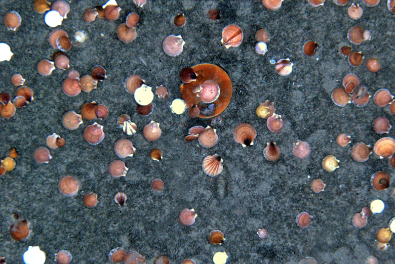
The federal survey also uses a towed camera known as “HabCam” to photograph sea scallops on the bottom. The plan was to use HabCam in the Great South Channel, on the Northern Flank, and in Closed Area II North, but an uncharted boulder and foul weather precluded this.
The New England Fishery Management Council subsequently requested additional photographic data sampling of the Northern Flank and Closed Area II North if possible. Comprehensive survey data are a hallmark of sea scallop assessments and directly feed into the development of management measures. This makes survey work a high priority for the council and the sea scallop industry.
The grant awarded to the University in May for Georges Bank-area surveys was increased in early July by 6,560 pounds of sea scallops ($62,320) to support five more research days to cover the additional areas. The original grant was for 45,809 pounds of sea scallops ($435,190).
In addition to tracking sea scallop aggregations, this project is also supporting development of an open-source computer algorithm for automating scallop counts and measurements from the images gathered.