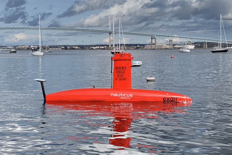
Last fall, a team of ocean researchers sent an uncrewed, slender, submarine-shaped vehicle packed with scientific electronics into offshore wind farm areas off southern New England. It was a test of how well the vehicle could operate and gather data in the area. It could be an important step toward a safe, efficient solution for monitoring marine life and habitats in places where our larger research vessels and aircraft can’t operate.
The vehicle traveled more than 3,000 miles along the transect lines we provided, recording throughout the tidal cycles. “We wanted to know what data we could get, how close we could get to the wind turbines, and could we see tidal influences?” said Michael Jech. Jech is a fishery biologist at our science center who led the project. He specializes in using sound to study life in the ocean.
“The DriX surveyed at 6 to 10 knots, within 20 meters of turbine structures, and housed the acoustics package we needed,” he said. Jech and other researchers are still plowing through the collected data. “So far we can see fish and plankton changing their distribution around the turbines over the course of a day,” said Jech, “but we are still working with the data.”
New Ways to Capture Critical Data
For more than 50 years, our science center has carried out a comprehensive monitoring program. We gather data researchers need to understand marine fishery stocks, ocean conditions, and habitat. We conduct this work consistently, throughout the year, using standard practices from year to year. This has resulted in some of the world’s longest running data sets reflecting changes in the ocean and its sealife over time.
This monitoring effort covers U.S. waters of the Mid-Atlantic, New England, and the farthest northern reaches of the Gulf of Maine, from nearshore to the edges of our continental shelf. However, the advent of offshore wind energy development means that there will be gaps in this picture because our ships and aircraft will not be able to get into these areas safely or consistently.
“Finding and adapting new ways of collecting data in areas where our survey vessels and aircraft can no longer go is crucial to maintaining our data streams which are fundamental to effectively manage marine resources for food and conservation,” said Andrew Lipsky, “this trial is a great example of our efforts to do so.”
Lipsky leads our Offshore Wind Ecology Branch. It’s part of our intense effort to prepare for and manage changes in our work that this new source of renewable energy will bring.

DriX Trial Operations
In this trial we contracted with Exail, a company that specializes in advanced technologies for monitoring in “hostile” environments, from the deep ocean to outer space. They provided a vessel called the DriX, which operates at the surface, with or without supervision. We provided our monitoring plans, which tested different transects (the path that the DriX would follow) within three wind energy areas, and different survey patterns. Some were typical grids, while others were spirals around turbines. This uncrewed survey achieved coverage for more than 3,000 miles of survey path.

The NOAA R/V Gloria Michelle assisted during the initial launch and with testing and calibration exercises. The ship escorted the DriX from Jamestown to Block Island after all system checks. The Gloria Michelle is a 72-foot converted shrimp trawler. It operates in coastal waters along the Northeastern United States, homeported at the Woods Hole Laboratory.
The DriX launched from Jamestown, Rhode Island, and operated for 20 days, including refueling and maintenance time. The scientific acoustic equipment was carried in its gondola, which sits about 5 feet below the waterline. For this experiment, it was outfitted with a SeaPiX multibeam sonar, Kongsberg EK80 (an echosounder), and a Nortek Signature500 acoustic doppler current profiler. Together, these instruments provided accurate water column coverage, detected fish and plankton fields, and recorded information about the seabed below the vehicle.

The DriX was monitored around the clock with a variety of radars, cameras, and an automatic identification system that transmits a ship’s position so that other ships are aware of its position.
Teams at the University of Rhode Island’s Inner Space Center and the Exail Maritime Autonomy hub in La Ciotat, France provided 24-hour satellite-based supervision. The DriX is outfitted with a satellite transmitter to transfer data in real time, including:
- What was being collected
- How the vehicle was operating
- What the topside camera was seeing
When the DriX was close to turbine structures and in high-traffic situations, the Exail team took navigational control for safe maneuvering. At other times the vehicle operated autonomously. “In waters further offshore, there are fewer obstacles to avoid, so conditions there are better suited for fully autonomous operations,“ said Jech. “Since wind energy areas are relatively close to shore there’s significant vessel traffic to be aware of, we used supervised operations,” he said.
The video and infrared cameras helped with situational awareness, as well as a bonus observation or two. For example, there are passive acoustic recorders in the area. The video feed showed small cetaceans were curious about the vehicle and swam near it. These animals make noises that can be captured by the recorders. By comparing the time stamps on that footage with those from the passive acoustic data collected, it may be possible to confirm the species involved and confirm the species identification from the recordings.
Next Steps
NOAA and the Bureau of Ocean Energy Management have developed a survey mitigation strategy. These trials are part of the strategy goal to identify and develop new survey approaches.
“For example, this particular vehicle does not capture biological samples needed to understand fish age and growth, food habits and reproduction. So that’s another critical gap we will need to fill,” said Lipsky. “We are considering using smaller vessels and new methods such as capturing and analyzing environmental DNA as possible ways forward.”

We are working to understand how remotely collected data can be used to supplement existing data collections and better understand marine ecosystems. For example, we are determining how stock assessment and ecosystem scientists could incorporate these data, what they would need, and at what time and geographic scales.
NOAA is investing more in uncrewed systems to expand our capabilities in other areas, including hurricane research and seafloor mapping. Asoffshore wind energy development grows around the nation, we are working toenable sustainable, safe, inclusive and informed development. Uncrewed systems can serve as a critical tool for performing surveys in wind farm regions that are difficult to access using standard survey methods.