Chesapeake Bay CMECS Substrate Component Geodatabase
Data Set (DS) | NMFS Office Of Habitat Conservation (OHC)GUID: gov.noaa.nmfs.inport:29682 | Updated: August 15, 2023 | Published / External
Summary
Short Citation
NMFS Office Of Habitat Conservation, 2025: Chesapeake Bay CMECS Substrate Component Geodatabase, https://www.fisheries.noaa.gov/inport/item/29682.
Full Citation Examples
The CMECS Component Geodatabase houses component layers for the entire Chesapeake Bay. Available component layers currently include the Substrate Component. Future component additions will include Biotic and Geoform.
Distribution Information
-
ArcGIS geodatabase with associated files are compressed into a *.zip file.
There are no constraints to the access of these data.
These data are constrained by uses for navigation. These data will not be used for navigation.
Child Items
No Child Items for this record.
Contact Information
Point of Contact
Jay V Lazar
jay.lazar@noaa.gov
410-375-0899
Metadata Contact
Jay V Lazar
jay.lazar@noaa.gov
410-375-0899
Extents
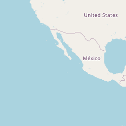


-77.53333333333° W,
-75.45555555556° E,
39.69166666667° N,
36.84444444444° S
The Chesapeake Bay and it's tidally influenced waters.