2011 USVI Larval Reef Fish Distribution and Supply Study
Data Set (DS) | Southeast Fisheries Science Center (SEFSC)GUID: gov.noaa.nmfs.inport:30703 | Updated: March 27, 2024 | Published / External
Summary
Short Citation
Southeast Fisheries Science Center, 2024: 2011 USVI Larval Reef Fish Distribution and Supply Study, https://www.fisheries.noaa.gov/inport/item/30703.
Full Citation Examples
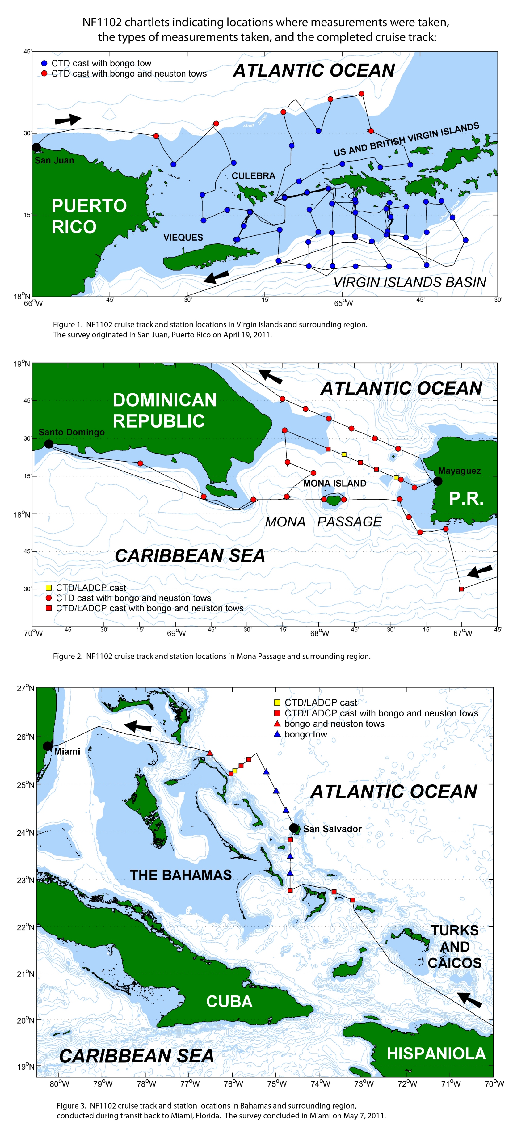
Contains the final, processed data from the joint Coral Reef Ecosystem Research (CRER) and Reef Fish Resource cruise conducted aboard the NOAA Ship NANCY FOSTER between 19 April 2011 and 7 May 2011 (NF-10-01 and NF-10-02).
NOAA CRUISE ID:NF-11-02
US STATE DEPARTMENT CRUISE ID:DOS F2010-122
SHIP NAME: NOAA Ship Nancy Foster
OPERATING AGENCY: National Oceanic and Atmospheric Administration (NOAA)
PROJECT TITLE: Coral Reef Ecosystem Research
CRUISE DATES:
19 April 2011 through 7 May 2011
The data includes:
CTD: processed data from all conductivity, temperature, depth (CTD) casts
LADCP: processed data from all lowered acoustic Doppler profiler (LADCP) casts
SADCP: processed hull-mounted acoustic Doppler current profiler (SADCP) data from the completed cruise ship track
TSG: processed sea surface, flow-through data collected with the ship's thermosalinograph (TSG) and fluorometer, covering the completed cruise ship track
FISH: processed larval fish data collected from the various net tows
(BONGO, MOCNESS, etc.) conducted during the cruise.
Distribution Information
-
All files in this folder/directory
-
Directory of zipped CTD Files, Zipped LADCP files, and Zipped CTD Plots
None
Controlled Theme Keywords
DOC/NOAA/NMFS/SEFSC, DOC/NOAA/OAR/AOML, WATER TEMPERATURE
Child Items
| Type | Title |
|---|---|
| Entity | CTD Data 2011 |
| Document | CTD Data 2011 Graphs |
| Document | Cruise Report for 2011 -- nf1102 - DOS F2010-122 |
| Document | LADCP Profiles 2011 |
| Document | NF-11-02 cruise track Map with Gear Shown |
| Document | NF1102_Fish_Data.readme |
| Entity | NF1102_Fish_Data.xls |
| Entity | NF1102_OS150_surface_vels.asc |
| Entity | NF1102_TSG.xls |
| Entity | nf1102_ladcp_data.zip |
| Document | readme_NF-1102.pdf |
URLs
URL 1
| URL: | https://www.ncei.noaa.gov/archive/accession/0273560/1.1/data/0-data/NF1102_State_Dept_DVD/NF1102_cruise_track.jpg |
|---|---|
| Name: | Cruise Track With Gear For Cruise NF-11-02 |
| URL Type: |
Browse Graphic
|
| File Resource Format: | jpg |
Child Items
Rubric scores updated every 15m
| Type | Title |
|---|---|
| Entity | CTD Data 2011 |
| Document | CTD Data 2011 Graphs |
| Document | Cruise Report for 2011 -- nf1102 - DOS F2010-122 |
| Document | LADCP Profiles 2011 |
| Document | NF-11-02 cruise track Map with Gear Shown |
| Document | NF1102_Fish_Data.readme |
| Entity | NF1102_Fish_Data.xls |
| Entity | NF1102_OS150_surface_vels.asc |
| Entity | NF1102_TSG.xls |
| Entity | nf1102_ladcp_data.zip |
| Document | readme_NF-1102.pdf |