Accuracy Assessment Field Data for the Main Eight Hawaiian Islands UTM Zone 5
Data Set (DS) | National Centers for Coastal Ocean Science (NCCOS)GUID: gov.noaa.nmfs.inport:39384 | Updated: May 30, 2023 | Published / External
Summary
Short Citation
National Centers for Coastal Ocean Science, 2025: Accuracy Assessment Field Data for the Main Eight Hawaiian Islands UTM Zone 5, https://www.fisheries.noaa.gov/inport/item/39384.
Full Citation Examples
This project is a cooperative effort between the National Ocean Service, National Centers for Coastal Ocean Science, Center for Coastal Monitoring and Assessment, the University of Hawaii, BAE Systems Spectral Solutions and Analytical Laboratories of Hawaii, LLC. The goal of the work was to incorporate previously developed mapping methods to produce coral reef habitat maps for the Main Eight Hawaiian Islands. GPS field observations were used to establish the thematic accuracy of this thematic product. 39 benthic habitat characterizations were completed in UTM Zone 5 for this work.
Distribution Information
No Distributions available.
Access Constraints:None
Not for navigation
Controlled Theme Keywords
environment, geoscientificInformation, oceans
Child Items
| Type | Title |
|---|---|
| Entity | mehi_aa_zone_5 |
Contact Information
Point of Contact
NCCOS Scientific Data Coordinator
NCCOS.data@noaa.gov
Metadata Contact
NCCOS Scientific Data Coordinator
NCCOS.data@noaa.gov
Extents
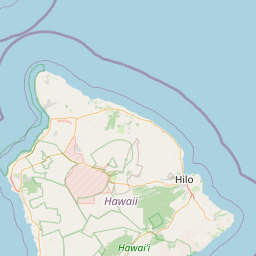


-156.060298° W,
-155.985947° E,
19.836202° N,
19.667532° S
2004 - 2006