Sensitivity of Coastal Environments and Wildlife to Spilled Oil: South Florida: FISH (Fish Polygons)
Data Set (DS) | Office of Response and Restoration (ORR)GUID: gov.noaa.nmfs.inport:40699 | Updated: May 30, 2023 | Published / External
Summary
Short Citation
Office of Response and Restoration, 2025: Sensitivity of Coastal Environments and Wildlife to Spilled Oil: South Florida: FISH (Fish Polygons), https://www.fisheries.noaa.gov/inport/item/40699.
Full Citation Examples
This data set contains sensitive biological resource data for marine and estuarine fish species in South Florida. Vector polygons in this data set represent fish distribution, concentration areas, nursery areas and spawning areas. Species specific abundance, seasonality, status, life history, and source information are stored in relational data tables (described below) designed to be used in conjunction with this spatial data layer. This data set comprises a portion of the ESI data for South Florida. ESI data characterize the marine and coastal environments and wildlife by their sensitivity to spilled oil. The ESI data include information for three main components: shoreline habitats, sensitive biological resources, and human-use resources.
Distribution Information
-
Downloadable Data
None
DO NOT USE MAPS FOR NAVIGATIONAL PURPOSES.
Besides the above warning, there are no use constraints on these data. Note that the ESI database should not be used to the exclusion of other pertinent data or information held by state or federal agencies or other organizations. Likewise, information contained in the database cannot be used in place of consultations with environmental, natural resource, and cultural resource agencies, or in place of field surveys. Recognize that the information contained in the ESI database represents known concentration areas or occurrences of natural, cultural, and human-use resources, but does not necessarily represent the full distribution or range of each species or resource. This is particularly important to recognize when considering potential impacts to protected resources, such as endangered species, wetlands, etc. Acknowledgment of the originators, publishers, contributors, and sources listed would be appreciated in products derived from these data.
Controlled Theme Keywords
biota, environment
Contact Information
Point of Contact
ESI Program Manager
orr.esi@noaa.gov
Metadata Contact
ESI Program Manager
orr.esi@noaa.gov
Extents
-82.933° W,
-80° E,
26.375° N,
24.5° S
1972 - 2013
Item Identification
| Title: | Sensitivity of Coastal Environments and Wildlife to Spilled Oil: South Florida: FISH (Fish Polygons) |
|---|---|
| Short Name: | fl_south_fish |
| Status: | Completed |
| Publication Date: | 2013-04 |
| Abstract: |
This data set contains sensitive biological resource data for marine and estuarine fish species in South Florida. Vector polygons in this data set represent fish distribution, concentration areas, nursery areas and spawning areas. Species specific abundance, seasonality, status, life history, and source information are stored in relational data tables (described below) designed to be used in conjunction with this spatial data layer. This data set comprises a portion of the ESI data for South Florida. ESI data characterize the marine and coastal environments and wildlife by their sensitivity to spilled oil. The ESI data include information for three main components: shoreline habitats, sensitive biological resources, and human-use resources. |
| Purpose: |
The ESI data were collected, mapped, and digitized to provide environmental data for oil spill planning and response. The Clean Water Act with amendments by the Oil Pollution Act of 1990 requires response plans for immediate and effective protection of sensitive resources. |
| Notes: |
1742 |
| Other Citation Details: |
Prepared by Research Planning, Inc., Columbia, South Carolina for the National Oceanic and Atmospheric Administration (NOAA), National Ocean Service, Office of Response and Restoration, Emergency Response Division, Seattle, Washington. |
Keywords
Theme Keywords
| Thesaurus | Keyword |
|---|---|
| ISO 19115 Topic Category |
biota
|
| ISO 19115 Topic Category |
environment
|
| UNCONTROLLED | |
| NOS Data Explorer Topic Category | Environmental Monitoring |
| None | Coastal resources |
| None | Coastal Zone Management |
| None | Environmental Monitoring |
| None | ESI |
| None | Fish |
| None | Oil spill planning |
| None | Sensitivity maps |
| None | Wildlife |
Spatial Keywords
| Thesaurus | Keyword |
|---|---|
| UNCONTROLLED | |
| None | South Florida |
Physical Location
| Organization: | Office of Response and Restoration |
|---|---|
| City: | Silver Spring |
| State/Province: | MD |
Data Set Information
| Data Set Scope Code: | Data Set |
|---|---|
| Maintenance Frequency: | None Planned |
| Data Presentation Form: | vector digital data |
| Entity Attribute Overview: |
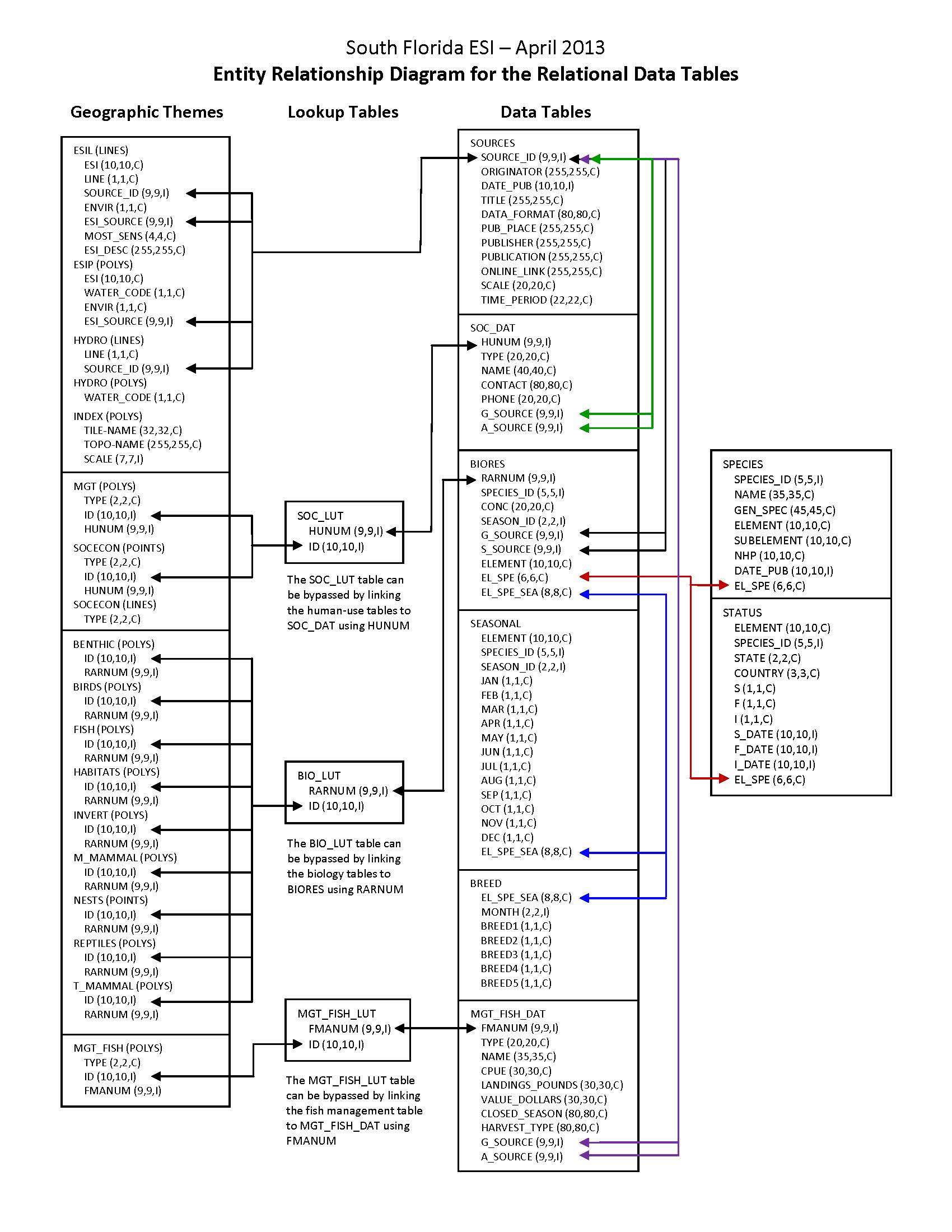
In addition to the geographic data layers, six relational attribute or data tables (BIORES, BREED, SEASONAL, SOURCES, SPECIES, and STATUS) are used to store the complex biological data in the ESI data structure. The geographic data layer containing biological resource information (in this case, FISH) is linked to the Biological Resources table (BIORES) using the unique ID and the lookup table BIO_LUT, or it can be linked directly using RARNUM. The ID is a unique combination of the atlas number (for the South Florida atlas, the number is 221), an element/layer specific number (BIRDS are layer 1, FISH are layer 2, etc.), and a unique record number. The RARNUM represents a unique combination of species, seasonalities, concentrations, and source information. For each of these groupings, a number is generated. That number is concatenated with the atlas number to create a "resource at risk" number that is unique across atlases. BIORES and the other relational data tables are described in the Detailed_Description sections. See the Browse_Graphic section for a link to the entity-relationship diagram, which describes the way these tables relate to the geographic data layers and other attribute tables in the ESI data structure. Due to the complexity of the relational database model, the data items are also post-processed into a flat file format. This table, called BIOFILE, may be used in place of the relational files to ease simple data queries. The items in the flat file are ELEMENT, SUBELEMENT, NAME, GEN_SPEC, S, F, NHP, DATE_PUB, CONC, JAN, FEB, MAR, APR, MAY, JUN, JUL, AUG, SEP, OCT, NOV, DEC, BREED1, BREED2, BREED3, BREED4, BREED5, RARNUM, G_SOURCE, S_SOURCE, and BREED. All of these items are the same as their counterparts in the individual data tables (described in the Detailed_Description sections), except the BREED1-BREED5 and BREED items. BREED is a newly generated variable used to link to the BREED_DT data table, a modified, more compact version of the relational BREED data table. BREED1-BREED5 give a text summary of when each life stage occurs within the associated map object. The life stages referred to are the same as those listed in the Detailed_Description of the BREED data table. The link to the BIOFILE may be made through the BIO_LUT, using ID to link to RARNUM, or BIOFILE may be linked directly to the RARNUM in each of the geographic layer's attribute data tables. As mentioned, BREED_DT is an auxiliary support data table to the flat file structure, which allows the user to do searches based on month for seasonal breeding activities. The link from the flat file to BREED_DT is the BREED item. A second supporting data table is SOURCES. This is the same as the source file described above, and the link from the flat file is both G_SOURCE and S_SOURCE. It should be noted that although the flat file eases data query, it is not a normalized database structure, and actual updates performed by the states and other responsible agencies should be done using the relational data tables. The entity-relationship diagram describing relationships between attribute tables in the ESI data structure does NOT include the BIOFILE data table, and this data table is NOT described in a Detailed_Description section. |
| Entity Attribute Detail Citation: |
A complete description of entity types, attributes, and attribute values for ESI atlases can be found in the NOAA ESI Guidelines (http://response.restoration.noaa.gov/esi_guidelines). |
| Distribution Liability: |
Although these data have been processed successfully on a computer system at the National Oceanic and Atmospheric Administration (NOAA), no warranty, expressed or implied, is made by NOAA regarding the utility of the data on any other system, nor shall the act of distribution constitute any such warranty. NOAA warrants the delivery of this product in computer-readable format. If problems are encountered in downloading the ESI data or with file corruption, contact NOAA (see Distributor). These data represent a snapshot in time and temporal changes may have occurred. The data are not intended to include all biological or human-use resources present in an area; they focus on species and resources particularly sensitive to oiling. In the event of a spill, they should be used for a first assessment only. The data providers are the experts with regard to individual resources. They should be contacted to confirm if more current data exist or if in-depth information is needed about a particular resource. |
| Data Set Credit: | This project was supported by the National Oceanic and Atmospheric Administration (NOAA), National Ocean Service (NOS), Office of Response and Restoration (OR&R), Emergency Response Division (ERD), Seattle, Washington; the Department of Homeland Security (DHS), United States Coast Guard (USCG), Office of Incident Management and Preparedness, Washington, D.C.; and the Fish and Wildlife Research Institute (FWRI), Florida Fish and Wildlife Conservation Commission (FWC), St. Petersburg, Florida. |
Support Roles
Data Steward
| Date Effective From: | 2013-04 |
|---|---|
| Date Effective To: | |
| Contact (Position): | ESI Program Manager |
| Address: |
7600 Sand Point Way NE Seattle, WA 98115 |
| Email Address: | orr.esi@noaa.gov |
Distributor
| Date Effective From: | 2013-04 |
|---|---|
| Date Effective To: | |
| Contact (Position): | ESI Program Manager |
| Address: |
7600 Sand Point Way NE Seattle, WA 98115 |
| Email Address: | orr.esi@noaa.gov |
Metadata Contact
| Date Effective From: | 2013-04 |
|---|---|
| Date Effective To: | |
| Contact (Position): | ESI Program Manager |
| Address: |
7600 Sand Point Way NE Seattle, WA 98115 |
| Email Address: | orr.esi@noaa.gov |
Point of Contact
| Date Effective From: | 2013-04 |
|---|---|
| Date Effective To: | |
| Contact (Position): | ESI Program Manager |
| Address: |
7600 Sand Point Way NE Seattle, WA 98115 |
| Email Address: | orr.esi@noaa.gov |
Extents
| Currentness Reference: | The data were compiled during 2011-2013. The currentness dates for the data range from 1972 to 2013 and are documented in the Lineage section. |
|---|
Extent Group 1
Extent Group 1 / Geographic Area 1
| W° Bound: | -82.933 | |
|---|---|---|
| E° Bound: | -80 | |
| N° Bound: | 26.375 | |
| S° Bound: | 24.5 |
Extent Group 1 / Time Frame 1
| Time Frame Type: | Range |
|---|---|
| Start: | 1972 |
| End: | 2013 |
Spatial Information
Spatial Representation
Representations Used
| Vector: | Yes |
|---|
Vector Representation 1
| Complex Object Present?: | Yes |
|---|---|
| Complex Object Count: | 33770 |
| Curve Object Present?: | Yes |
| Curve Object Count: | 3591446 |
| Point Object Present?: | Yes |
| Point Object Count: | 33769 |
| Surface Object Present?: | Yes |
| Surface Object Count: | 60755 |
Access Information
| Security Class: | Unclassified |
|---|---|
| Data Access Procedure: |
Contact NOAA if you require the ESI data be provided to you on CD/DVD (see Distributor). ESI data are processed into multiple formats to make them useful to a wider community of GIS/mapping users. Distribution formats include ARC export files, Shapefiles, and a file Geodatabase (the recommended format). The database files are distributed both in the NOAA standard relational database format (see NOAA Technical Memorandum NOS ORCA 115) and in a simplified desktop flat file format. This metadata document includes information on both of these database formats.; |
| Data Access Constraints: |
None |
| Data Use Constraints: |
DO NOT USE MAPS FOR NAVIGATIONAL PURPOSES. Besides the above warning, there are no use constraints on these data. Note that the ESI database should not be used to the exclusion of other pertinent data or information held by state or federal agencies or other organizations. Likewise, information contained in the database cannot be used in place of consultations with environmental, natural resource, and cultural resource agencies, or in place of field surveys. Recognize that the information contained in the ESI database represents known concentration areas or occurrences of natural, cultural, and human-use resources, but does not necessarily represent the full distribution or range of each species or resource. This is particularly important to recognize when considering potential impacts to protected resources, such as endangered species, wetlands, etc. Acknowledgment of the originators, publishers, contributors, and sources listed would be appreciated in products derived from these data. |
Distribution Information
Distribution 1
| Download URL: | http://response.restoration.noaa.gov/esi_download |
|---|---|
| Distributor: | |
| Description: |
Downloadable Data |
| File Type (Deprecated): | Multiple formats |
URLs
URL 1
| URL: | http://response.restoration.noaa.gov/esi |
|---|---|
| URL Type: |
Online Resource
|
URL 2
| URL: | http://response.restoration.noaa.gov/esi_download |
|---|---|
| URL Type: |
Online Resource
|
URL 3
| URL: | http://response.restoration.noaa.gov/esi_guidelines |
|---|---|
| URL Type: |
Online Resource
|
URL 4
| URL: | http://response.restoration.noaa.gov/sites/default/files/esimaps/gisdata/SouthFlorida_2013_datafig.jpg |
|---|---|
| URL Type: |
Browse Graphic
|
| File Resource Format: | JPEG |
| Description: |
Depicts the relationships between spatial data layers and attribute data tables for the South Florida ESI data. |
URL 5
| URL: | http://response.restoration.noaa.gov/sites/default/files/esimaps/gisdata/SouthFlorida_2013_datafig2.jpg |
|---|---|
| URL Type: |
Browse Graphic
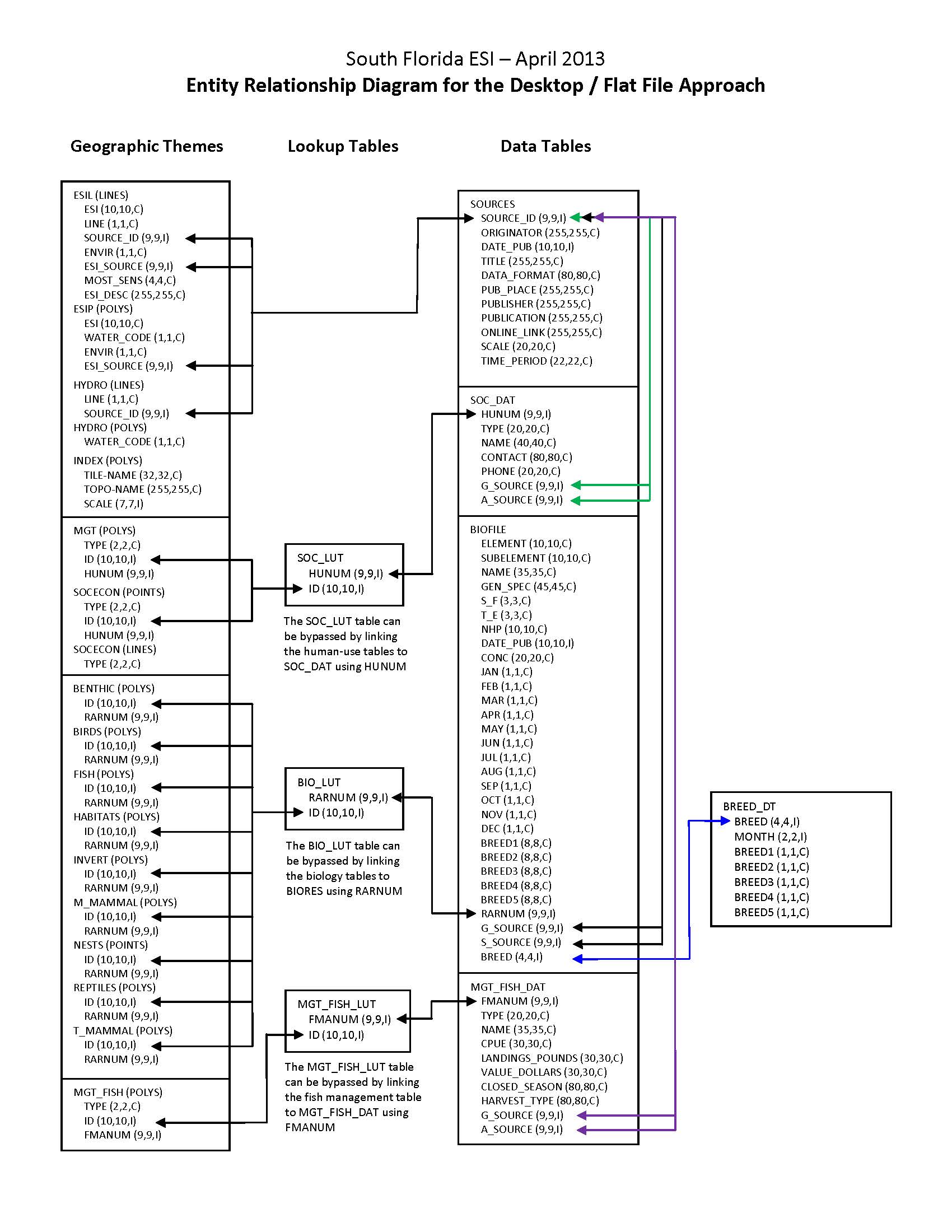
|
| File Resource Format: | JPEG |
| Description: |
Depicts the relationships between spatial data layers and desktop data tables for the South Florida ESI data. |
Activity Log
Activity Log 1
| Activity Date/Time: | 2014-06-17 |
|---|---|
| Description: |
Date that the source FGDC record was last modified. |
Activity Log 2
| Activity Date/Time: | 2017-04-05 |
|---|---|
| Description: |
Converted from Content Standards for Digital Geospatial Metadata (version FGDC-STD-001-1998) using 'fgdc_to_inport_xml.pl' script. Contact Tyler Christensen (NOS) for details. |
Activity Log 3
| Activity Date/Time: | 2017-09-13 |
|---|---|
| Description: |
Partial upload of Spatial Info section only. |
Activity Log 4
| Activity Date/Time: | 2017-11-01 |
|---|---|
| Description: |
Replaced entire Lineage section to populate new Source Contribution field. |
Activity Log 5
| Activity Date/Time: | 2018-02-08 |
|---|---|
| Description: |
Partial upload of Positional Accuracy fields only. |
Technical Environment
| Description: |
The software packages used to develop the atlas are Environmental Systems Research Institute's ARC/INFO(R) (version 10.0) and SQL SERVER(R) (version 2005). The hardware configuration is PCs with Windows Operating System 7. The Spatial_Data_Organization Information section refers only to the source files in the ARC export format. The following files are included in the data set: benthic.e00, birds.e00, esil.e00, esip.e00, fish.e00, habitats.e00, hydro.e00, index.e00, invert.e00, m_mammal.e00, mgt.e00, mgt_fish.e00, nests.e00, reptiles.e00, socecon.e00, and t_mammal.e00. Associated relational and desktop data tables provided in Arc export and text format are bio_lut.e00, biofile.e00, biores.e00, breed.e00, breed_dt.e00, mgt_fish_dat.e00, mgt_fish_lut.e00, seasonal.e00, soc_dat.e00, soc_lut.e00, sources.e00, species.e00, and status.e00. |
|---|
Data Quality
| Accuracy: |
A multi-stage error checking process is used to verify both attribute accuracy and logical consistency throughout data production. The process includes a standardized data entry methodology, hardcopy data review by in-house and external resource experts, a final Quality Assurance/Quality Control (QA/QC) process, and multiple automated logical consistency checks. Quantitative data (such as densities, counts, abundances, or concentrations) provided by resource experts for inclusion in the data set may vary widely in attribute accuracy, depending upon the methodology used to collect and compile such data. For a more detailed evaluation of source data attribute accuracy, contact the sources listed in the Lineage section. |
|---|---|
| Horizontal Positional Accuracy: |
Spatial components for the biological data layers can come from expert interviews, hardcopy, or digital sources. Some of the spatial components of the biological data layers may have been developed using regional experts who estimate concentration areas. It is difficult to estimate the positional accuracy of such data, except to state that they are compiled on hardcopy base maps with a scale of 1:24,000. Some of the spatial components of the biological data sets are developed from pre-existing digital or hardcopy sources and reflect the positional accuracy of these original data. Note that biological resource data by their very nature are considered "fuzzy", and this should be understood when considering the positional accuracy of vector digital objects representing these resources. See the Lineage and Process_Description sections for more information on the original source data and how these data were integrated or manipulated to create the final data set. |
| Completeness Report: |
These data represent a synthesis of expert knowledge, digital data and hardcopy maps. These data do not necessarily represent all fish occurrences in South Florida. The following species are included in this data set: (Species_ID, Common Name, Scientific Name [n/a if not applicable]): 65, Bluefish, Pomatomus saltatrix; 107, Spotted seatrout, Cynoscion nebulosus; 109, Red drum, Sciaenops ocellatus; 112, Gulf flounder, Paralichthys albigutta; 113, Bay anchovy, Anchoa mitchilli; 116, Striped mullet, Mugil cephalus; 117, Pinfish, Lagodon rhomboides; 119, Silver perch, Bairdiella chrysoura; 122, Black drum, Pogonias cromis; 126, King mackerel, Scomberomorus cavalla; 127, Spanish mackerel, Scomberomorus maculatus; 128, Blue runner, Caranx crysos; 131, Great barracuda, Sphyraena barracuda; 134, Cobia, Rachycentron canadum; 136, Dolphin, Coryphaena hippurus; 137, Sheepshead, Archosargus probatocephalus; 140, Ladyfish, Elops saurus; 141, Common snook, Centropomus undecimalis; 142, Crevalle jack, Caranx hippos; 143, Tarpon, Megalops atlanticus; 268, Silver seatrout, Cynoscion nothus; 272, Rainbow runner, Elagatis bipinnulata; 278, Little tunny, Euthynnus alletteratus; 287, Hardhead catfish, Arius felis; 288, Atlantic tripletail, Lobotes surinamensis; 299, Rainwater killifish, Lucania parva; 303, Permit, Trachinotus falcatus; 306, Gray snapper, Lutjanus griseus; 307, Lane snapper, Lutjanus synagris; 310, Atlantic spadefish, Chaetodipterus faber; 315, Blacktip shark, Carcharhinus limbatus; 317, Bull shark, Carcharhinus leucas; 326, Bonnethead shark, Sphyrna tiburo; 327, Dwarf seahorse, Hippocampus zosterae; 335, Silversides, n/a; 343, Yellow jack, Caranx bartholomaei; 344, Bar jack, Caranx ruber; 345, Spotfin butterflyfish, Chaetodon ocellatus; 347, Round scad, Decapterus punctatus; 350, Tomtate, Haemulon aurolineatum; 351, Slippery dick, Halichoeres bivittatus; 352, Blue angelfish, Holacanthus bermudensis; 356, Greater amberjack, Seriola dumerili; 358, Cocoa damselfish, Stegastes variabilis; 362, Southern stingray, Dasyatis americana; 366, Hogchoker, Trinectes maculatus; 369, Code goby, Gobiosoma robustum; 377, Gulf toadfish, Opsanus beta; 384, Spotted eagle ray, Aetobatus narinari; 389, Nassau grouper, Epinephelus striatus; 412, Mojarras, Eucinostomus spp.; 430, Lookdown, Selene vomer; 433, Gulf pipefish, Syngnathus scovelli; 438, Scalloped hammerhead, Sphyrna lewini; 495, Gray triggerfish, Balistes capriscus; 497, Sergeant major, Abudefduf saxatilis; 512, Coney, Cephalopholis fulva; 514, Mutton snapper, Lutjanus analis; 515, Yellowtail snapper, Ocyurus chrysurus; 518, Goliath grouper, Epinephelus itajara; 520, White grunt, Haemulon plumierii; 521, Blue marlin, Makaira nigricans; 522, Yellowfin tuna, Thunnus albacares; 523, Swordfish, Xiphias gladius; 525, Bonefish, Albula vulpes; 580, Tarpon snook, Centropomus pectinatus; 598, Anchovies, Anchoa sp.; 611, Lined sole, Achirus lineatus; 612, Speckled worm eel, Myrophis punctatus; 638, Wahoo, Acanthocybium solandri; 719, Hogfish, Lachnolaimus maximus; 720, Ocean surgeon, Acanthurus bahianus; 721, Doctorfish, Acanthurus chirurgus; 722, Blue tang, Acanthurus coeruleus; 724, Cottonwick grunt, Haemulon melanurum; 725, Clown wrasse, Halichoeres maculipinna; 726, Queen angelfish, Holacanthus ciliaris; 727, Rock beauty, Holacanthus tricolor; 729, Mahogany snapper, Lutjanus mahogoni; 732, Bluehead, Thalassoma bifasciatum; 734, Porkfish, Anisotremus virginicus; 736, Swordspine snook, Centropomus ensiferus; 737, Blue chromis, Chromis cyanea; 739, Sharpnose puffer, Canthigaster rostrata; 742, French grunt, Haemulon flavolineatum; 743, Squirrelfish, Holocentrus adscensionis; 748, Yellowtail damselfish, Microspathodon chrysurus; 752, Gray angelfish, Pomacanthus arcuatus; 753, French angelfish, Pomacanthus paru; 754, Blue parrotfish, Scarus coeruleus; 755, Rainbow parrotfish, Scarus guacamaia; 756, Redband parrotfish, Sparisoma aurofrenatum; 757, Stoplight parrotfish, Sparisoma viride; 759, African pompano, Alectis ciliaris; 775, Rock hind, Epinephelus adscensionis; 776, Red grouper, Epinephelus morio; 783, Bluestriped grunt, Haemulon sciurus; 791, Sailfish, Istiophorus platypterus; 797, Blackfin snapper, Lutjanus buccanella; 798, Cubera snapper, Lutjanus cyanopterus; 800, Dog snapper, Lutjanus jocu; 807, Black grouper, Mycteroperca bonaci; 823, Queen parrotfish, Scarus vetula; 826, Cero, Scomberomorus regalis; 835, Blackfin tuna, Thunnus atlanticus; 840, Houndfish, Tylosurus crocodilus crocodilus; 851, Sea bream, Archosargus rhomboidalis; 855, Horse-eye jack, Caranx latus; 864, Bermuda sea chub, Kyphosus sectatrix; 872, Scrawled cowfish, Acanthostracion quadricornis; 903, Ocean triggerfish, Canthidermis sufflamen; 968, Nurse shark, Ginglymostoma cirratum; 972, Schoolmaster, Lutjanus apodus; 1001, Blennies, n/a; 1017, Grunts, Haemulidae; 1018, Porgies, n/a; 1026, Cardinalfishes, n/a; 1027, Filefishes, n/a; 1031, Moray eels, n/a; 1042, Needlefishes, Belonidae; 1045, Scorpionfishes, n/a; 1046, Flying fishes, n/a; 1053, Lizardfishes, n/a; 1088, Lined seahorse, Hippocampus erectus; 1130, Dusky shark, Carcharhinus obscurus; 1146, Bluefin tuna, Thunnus thynnus; 1154, Snowy grouper, Hyporthodus niveatus; 1155, Warsaw grouper, Hyporthodus nigritus; 1156, Yellowedge grouper, Hyporthodus flavolimbatus; 1159, Smalltooth sawfish, Pristis pectinata; 1161, Cherubfish, Centropyge argi; 1162, Yellowtail reeffish, Chromis enchrysura; 1163, Sunshinefish, Chromis insolata; 1164, Brown chromis, Chromis multilineata; 1165, Purple reeffish, Chromis scotti; 1166, Creole wrasse, Clepticus parrae; 1168, Yellowhead wrasse, Halichoeres garnoti; 1169, Blackear wrasse, Halichoeres poeyi; 1170, Puddingwife, Halichoeres radiatus; 1171, Ballyhoo, Hemiramphus spp.; 1172, Tilefish, Lopholatilus chamaeleonticeps; 1173, Yellowhead jawfish, Opistognathus aurifrons; 1175, Dusky damselfish, Stegastes adustus; 1176, Longfin damselfish, Stegastes diencaeus; 1177, Beaugregory, Stegastes leucostictus; 1178, Bicolor damselfish, Stegastes partitus; 1179, Threespot damselfish, Stegastes planifrons; 1180, Banded butterflyfish, Chaetodon striatus; 1181, Bucktooth parrotfish, Sparisoma radians; 1182, Foureye butterflyfish, Chaetodon capistratus; 1183, Graysby, Cephalopholis cruentata; 1184, Midnight parrotfish, Scarus coelestinus; 1185, Princess parrotfish, Scarus taeniopterus; 1186, Redtail parrotfish, Sparisoma chrysopterum; 1187, Reef butterflyfish, Chaetodon sedentarius; 1188, Reef croaker, Odontoscion dentex; 1189, Sailors choice, Haemulon parra; 1190, Sand tilefish, Malacanthus plumieri; 1191, Smooth trunkfish, Rhinesomus triqueter; 1192, Spanish hogfish, Bodianus rufus; 1193, Striped parrotfish, Scarus iseri; 1194, Yellowtail parrotfish, Sparisoma rubripinne; 1195, Balao, Hemiramphus balao; 1196, Bank butterflyfish, Prognathodes aya; 1197, Banner goby, Microgobius microlepis; 1198, Barred hamlet, Hypoplectrus puella; 1199, Batfish, Ogcocephalus spp.; 1200, Bearded goby, Barbulifer ceuthoecus; 1201, Bluelip parrotfish, Cryptotomus roseus; 1202, Bridled goby, Coryphopterus glaucofraenum; 1203, Snake eels, Ophichthidae; 1204, Chain pipefish, Syngnathus louisianae; 1205, Clown goby, Microgobius gulosus; 1206, Dusky pipefish, Syngnathus floridae; 1207, Fantail mullet, Mugil trichodon; 1208, Fat snook, Centropomus parallelus; 1209, Fringed pipefish, Anarchopterus criniger; 1210, Frogfishes, Antennariidae; 1211, Goldspotted killifish, Floridichthys carpio; 1212, Hamlets, Hypoplectrus spp.; 1213, Key anchovy, Anchoa cayorum; 1214, Key blenny, Starksia starcki; 1215, Key silverside, Menidia conchorum; 1216, Key worm eel, Ahlia egmontis; 1217, Lemon shark, Negaprion brevirostris; 1218, Longsnout butterflyfish, Prognathodes aculeatus; 1219, Mangrove rivulus, Kryptolebias marmoratus; 1220, Neon goby, Elacatinus oceanops; 1221, Ornamental serranids, n/a; 1222, Speckled hind, Epinephelus drummondhayi; 1223, White marlin, Kajikia albida; 1224, Wreckfish, Polyprion americanus; 1225, Yellowcheek wrasse, Halichoeres cyanocephalus; 1226, Masked goby, Coryphopterus personatus; 1227, Peacock flounder, Bothus lunatus; 1228, Reef shark, Carcharhinus perezii; 1229, Ribbonfishes, Equetus spp. |
| Conceptual Consistency: |
A multi-stage error checking process, described in the above Attribute_Accuracy_Report, is used to verify both attribute accuracy and logical consistency throughout data production. This process includes multiple automated logical consistency checks that test the files for missing or duplicate data, rules for proper coding, GIS topological consistencies (such as dangles, unnecessary nodes, etc.), and SQL SERVER(R) to ARC/INFO(R) consistencies. After the data are delivered to NOAA, they are again subjected to a number of quality and consistency checks. In the process of checking for topological and database consistencies, new IDs and RARNUMs or HUNUMs are also generated. The new IDs are a combination of atlas number, element number, and record number. In addition, the value used to represent the element is modified to reflect the type of feature being mapped. In the case of an element that is normally represented by a point or polygon, a value of 20 is added to the standard element value for mapping of linear features. In the case where an element usually mapped as a polygon is represented by a point, a value of 30 is added to the regular element value. The RARNUMs are also modified to include the atlas number, so multiple atlases can be combined and RARNUMs remain unique. RARNUMs are redefined on an element basis, so "resource at risk" groupings will contain only a single element. HUNUMs are also modified to include the atlas number. |
Lineage
Sources
BLACK GROUPER AGGREGATIONS IN RELATION TO PROTECTED AREAS WITHIN THE FLORIDA KEYS NATIONAL MARINE SANCTUARY
| Contact Name: | EKLUND, A.M., D.B. MCLELLAN AND D.E. HARPER |
|---|---|
| Publish Date: | 2000-01-01 |
| Extent Type: | Range |
| Extent Start Date/Time: | 1997 |
| Extent End Date/Time: | 1998 |
| Source Contribution: |
FISH INFORMATION | Source Geospatial Form: document | Type of Source Media: PAPER |
BLACKTIP SHARK EFH
| Contact Name: | NATIONAL OCEANIC ATMOSPHERIC ADMINISTRATION (NOAA), NATIONAL MARINE FISHERIES SERVICE (NMFS), FISHERIES OFFICE OF SUSTAINABLE FISHERIES (OSF) |
|---|---|
| Publish Date: | 2009-01-01 |
| Extent Type: | Discrete |
| Extent Start Date/Time: | 2009 |
| Citation URL: | http://www.nmfs.noaa.gov/sfa/hms/EFH/shapefiles.htm |
| Source Contribution: |
FISH INFORMATION | Source Geospatial Form: vector digital data | Type of Source Media: online |
BLUE MARLIN EFH
| Contact Name: | NATIONAL OCEANIC ATMOSPHERIC ADMINISTRATION (NOAA), NATIONAL MARINE FISHERIES SERVICE (NMFS), FISHERIES OFFICE OF SUSTAINABLE FISHERIES (OSF) |
|---|---|
| Publish Date: | 2009-01-01 |
| Extent Type: | Discrete |
| Extent Start Date/Time: | 2009 |
| Citation URL: | http://www.nmfs.noaa.gov/sfa/hms/EFH/shapefiles.htm |
| Source Contribution: |
FISH INFORMATION | Source Geospatial Form: vector digital data | Type of Source Media: ONLINE |
BLUEFIN TUNA EFH
| Contact Name: | NATIONAL OCEANIC ATMOSPHERIC ADMINISTRATION (NOAA), NATIONAL MARINE FISHERIES SERVICE (NMFS), FISHERIES OFFICE OF SUSTAINABLE FISHERIES (OSF) |
|---|---|
| Publish Date: | 2009-01-01 |
| Extent Type: | Discrete |
| Extent Start Date/Time: | 2009 |
| Citation URL: | http://www.nmfs.noaa.gov/sfa/hms/EFH/shapefiles.htm |
| Source Contribution: |
FISH INFORMATION | Source Geospatial Form: vector digital data | Type of Source Media: ONLINE |
BONNETHEAD SHARK EFH
| Contact Name: | NATIONAL OCEANIC ATMOSPHERIC ADMINISTRATION (NOAA), NATIONAL MARINE FISHERIES SERVICE (NMFS), FISHERIES OFFICE OF SUSTAINABLE FISHERIES (OSF) |
|---|---|
| Publish Date: | 2009-01-01 |
| Extent Type: | Discrete |
| Extent Start Date/Time: | 2012 |
| Citation URL: | http://www.nmfs.noaa.gov/sfa/hms/EFH/shapefiles.htm |
| Source Contribution: |
FISH INFORMATION | Source Geospatial Form: vector digital data | Type of Source Media: ONLINE |
BUILDING SUSTAINABLE FISHERIES IN FLORIDA'S CORAL REEF ECOSYSTEM: POSITIVE SIGNS IN THE DRY TORTUGAS
| Contact Name: | AULT J.S., S.G. SMITH, J.A. BOHNSACK, J. LUO, D.E. HARPER, D.B. MCLELLAN |
|---|---|
| Publish Date: | 2006-01-01 |
| Extent Type: | Discrete |
| Extent Start Date/Time: | 2006 |
| Source Contribution: |
FISH INFORMATION | Source Geospatial Form: document | Type of Source Media: PAPER |
BULL SHARK EFH
| Contact Name: | NATIONAL OCEANIC ATMOSPHERIC ADMINISTRATION (NOAA), NATIONAL MARINE FISHERIES SERVICE (NMFS), FISHERIES OFFICE OF SUSTAINABLE FISHERIES (OSF) |
|---|---|
| Publish Date: | 2009-01-01 |
| Extent Type: | Discrete |
| Extent Start Date/Time: | 2009 |
| Citation URL: | http://www.nmfs.noaa.gov/sfa/hms/EFH/shapefiles.htm |
| Source Contribution: |
FISH INFORMATION | Source Geospatial Form: vector digital data | Type of Source Media: ONLINE |
DENSITIES OF COMMON REEF FISH BY GEOGRAPHIC REGION, HABITAT AND PROTECTION STATUS FROM THE REEF VISUAL CENSUS DATABASE
| Contact Name: | NATIONAL OCEANIC ATMOSPHERIC ADMINISTRATION (NOAA), SOUTHEAST FISHERIES SCIENCE CENTER (SEFSC) |
|---|---|
| Publish Date: | 2011-01-01 |
| Extent Type: | Range |
| Extent Start Date/Time: | 2008 |
| Extent End Date/Time: | 2011 |
| Source Contribution: |
FISH INFORMATION | Source Geospatial Form: vector digital data | Type of Source Media: PERSONAL COMMUNICATION |
DEVELOPMENT OF HABITAT SUITABILITY MODELS FOR BISCAYNE BAY AREA FISHES: ASSESSING SALINITY AFFINITY FROM ABUNDANCE DATA
| Contact Name: | SERAFY, J. AND D. JOHNSON |
|---|---|
| Publish Date: | 2008-01-01 |
| Extent Type: | Discrete |
| Extent Start Date/Time: | 2008 |
| Source Contribution: |
FISH INFORMATION | Source Geospatial Form: document | Type of Source Media: ONLINE |
DEVELOPMENTAL PATTERNS WITHIN A MULTISPECIES REEF FISHERY: MANAGEMENT APPLICATIONS FOR ESSENTIAL FISH HABITATS AND PROTECTED AREAS
| Contact Name: | LINDEMAN, K.C., R. PUGLIESE, G.T. WAUGH AND J.S. AULT |
|---|---|
| Publish Date: | 2000-01-01 |
| Extent Type: | Discrete |
| Extent Start Date/Time: | 2000 |
| Source Contribution: |
FISH INFORMATION | Source Geospatial Form: document | Type of Source Media: PAPER |
DISTRIBUTION AND ABUNDANCE OF FISH IN THE FLORIDA KEYS
| Contact Name: | ACOSTA, A. (FLORIDA FISH AND WILDLIFE CONSERVATION COMMISSION - FISH AND WILDLIFE RESEARCH INSTITUTE (FWC-FWRI)) |
|---|---|
| Publish Date: | 2013-01-01 |
| Extent Type: | Discrete |
| Extent Start Date/Time: | 2013 |
| Source Contribution: |
FISH INFORMATION | Source Geospatial Form: EXPERT KNOWLEDGE | Type of Source Media: PERSONAL COMMUNICATION |
DISTRIBUTION AND ABUNDANCE OF FISHES AND INVERTEBRATES IN GULF OF MEXICO ESTUARIES, VOL. I: DATA SUMMARIES.
| Contact Name: | NELSON, D.M. (EDITOR) ET AL (NOAA'S ESTUARINE LIVING MARINE RESOURCES PROGRAM) |
|---|---|
| Publish Date: | 1992-01-01 |
| Extent Type: | Discrete |
| Extent Start Date/Time: | 1998 |
| Citation URL: | http://ccma.nos.noaa.gov/ecosystems/estuaries/elmr.aspx |
| Source Contribution: |
FISH INFORMATION | Source Geospatial Form: document | Type of Source Media: paper |
DISTRIBUTION AND ABUNDANCE OF FISHES AND INVERTEBRATES IN GULF OF MEXICO ESTUARIES, VOLUME II: SPECIES LIFE HISTORY SUMMARIES
| Contact Name: | PATILLO, M.E. ET AL (NATIONAL OCEANIC AND ATMOSPHERIC ADMINISTRATION (NOAA) ESTUARINE LIVING MARINE RESOURCES PROGRAM) |
|---|---|
| Publish Date: | 1997-01-01 |
| Extent Type: | Discrete |
| Extent Start Date/Time: | 1997 |
| Source Contribution: |
FISH INFORMATION | Source Geospatial Form: document | Type of Source Media: paper |
DISTRIBUTION AND ABUNDANCE OF FISHES AND INVERTEBRATES IN SOUTHEAST ESTUARIES
| Contact Name: | NELSON, D.M. (EDITOR) ET AL (NOAA'S ESTUARINE LIVING MARINE RESOURCES PROGRAM) |
|---|---|
| Publish Date: | 1991-01-01 |
| Extent Type: | Discrete |
| Extent Start Date/Time: | 1991 |
| Source Contribution: |
FISH INFORMATION | Source Geospatial Form: document | Type of Source Media: paper |
DISTRIBUTION AND ABUNDANCE OF REEF FISH IN SOUTH FLORIDA
| Contact Name: | NATIONAL OCEANIC ATMOSPHERIC ADMINISTRATION (NOAA), SOUTHEAST FISHERIES SCIENCE CENTER (SEFSC), REEF FISH GROUP |
|---|---|
| Publish Date: | 2013-01-01 |
| Extent Type: | Discrete |
| Extent Start Date/Time: | 2013 |
| Source Contribution: |
FISH INFORMATION | Source Geospatial Form: EXPERT KNOWLEDGE | Type of Source Media: PERSONAL COMMUNICATION |
DISTRIBUTION AND SEASONALITY OF FISH IN SOUTH FLORIDA
| Contact Name: | MATHESON, E. (FISH AND WILDLIFE RESEARCH INSTITUTE (FWRI), FLORIDA FISH AND WILDLIFE CONSERVATION COMMISSION (FWC)) |
|---|---|
| Publish Date: | 2012-01-01 |
| Extent Type: | Discrete |
| Extent Start Date/Time: | 2012 |
| Source Contribution: |
FISH INFORMATION | Source Geospatial Form: EXPERT KNOWLEDGE BASED ON PUBLISHED LITERATURE | Type of Source Media: PERSONAL COMMUNICATION |
DUSKY SHARK EFH
| Contact Name: | NATIONAL OCEANIC ATMOSPHERIC ADMINISTRATION (NOAA), NATIONAL MARINE FISHERIES SERVICE (NMFS), FISHERIES OFFICE OF SUSTAINABLE FISHERIES (OSF) |
|---|---|
| Publish Date: | 2009-01-01 |
| Extent Type: | Discrete |
| Extent Start Date/Time: | 2009 |
| Citation URL: | http://www.nmfs.noaa.gov/sfa/hms/EFH/shapefiles.htm |
| Source Contribution: |
FISH INFORMATION | Source Geospatial Form: vector digital data | Type of Source Media: ONLINE |
ELASMOBRANCHS OF SOUTH FLORIDA
| Contact Name: | WILEY-LESCHER, TONYA (HAVEN WORTH CONSULTING) |
|---|---|
| Publish Date: | 2012-01-01 |
| Extent Type: | Discrete |
| Extent Start Date/Time: | 2012 |
| Source Contribution: |
FISH INFORMATION | Source Geospatial Form: EXPERT KNOWLEDGE | Type of Source Media: PERSONAL COMMUNICATION |
FINAL AMENDMENT 1 TO THE CONSOLIDATED ATLANTIC HIGHLY MIGRATORY SPECIES FISHERY MANAGEMENT PLAN ESSENTIAL FISH HABITAT
| Contact Name: | NATIONAL OCEANIC ATMOSPHERIC ADMINISTRATION (NOAA), NATIONAL MARINE FISHERIES SERVICE (NMFS), FISHERIES OFFICE OF SUSTAINABLE FISHERIES (OSF), HIGHLY MIGRATORY SPECIES MANAGEMENT DIVISION |
|---|---|
| Publish Date: | 2009-01-01 |
| Extent Type: | Discrete |
| Extent Start Date/Time: | 2009 |
| Source Contribution: |
FISH INFORMATION | Source Geospatial Form: document | Type of Source Media: ONLINE |
FINAL REPORT: SOUTH ATLANTIC FISHERY INDEPENDENT MONITORING PROGRAM WORKSHOP
| Contact Name: | WILLIAMS, ERIK H. AND JOHN CARMICHAEL |
|---|---|
| Publish Date: | 2009-01-01 |
| Extent Type: | Discrete |
| Extent Start Date/Time: | 2009 |
| Source Contribution: |
FISH INFORMATION | Source Geospatial Form: document | Type of Source Media: ONLINE |
FISH ASSEMBLAGES IN SEAGRASS HABITATS OF THE FLORIDA KEYS, FLORIDA: SPATIAL AND TEMPORAL CHARACTERISTICS
| Contact Name: | ACOSTA A., C. BARTELS, J. COLVOCORESSES, AND M.F.D. GREENWOOD |
|---|---|
| Publish Date: | 2007-01-01 |
| Extent Type: | Range |
| Extent Start Date/Time: | 1999 |
| Extent End Date/Time: | 2001 |
| Source Contribution: |
FISH INFORMATION | Source Geospatial Form: document | Type of Source Media: PAPER |
FISHBASE
| Contact Name: | FROESE, R. AND D. PAULY. EDITORS. |
|---|---|
| Publish Date: | 2011-01-01 |
| Extent Type: | Discrete |
| Extent Start Date/Time: | 2011 |
| Citation URL: | http://www.fishbase.org |
| Source Contribution: |
FISH INFORMATION | Source Geospatial Form: ONLINE DATABASE | Type of Source Media: ONLINE |
FISHERIES ASSESSMENT OF BISCAYNE BAY
| Contact Name: | BERKELEY, S.A. |
|---|---|
| Publish Date: | 1984-01-01 |
| Extent Type: | Discrete |
| Extent Start Date/Time: | 1984 |
| Source Contribution: |
FISH INFORMATION | Source Geospatial Form: document | Type of Source Media: EMAIL |
FISHERY MANAGEMENT PLAN FOR THE DOLPHIN AND WAHOO FISHERY OF THE ATLANTIC
| Contact Name: | SOUTH ATLANTIC FISHERY MANAGEMENT COUNCIL (SAFMC) |
|---|---|
| Publish Date: | 2003-01-01 |
| Extent Type: | Discrete |
| Extent Start Date/Time: | 2003 |
| Citation URL: | http://www.safmc.net/Portals/6/Library/FMP/DolphinWahoo/DolphinWahooFMP.pdf |
| Source Contribution: |
FISH INFORMATION | Source Geospatial Form: document | Type of Source Media: ONLINE |
ICTHYOLOGY DEPARTMENT SPECIES PROFILES
| Contact Name: | FLORIDA MUSEUM OF NATURAL HISTORY |
|---|---|
| Publish Date: | 2012-01-01 |
| Extent Type: | Discrete |
| Extent Start Date/Time: | 2012 |
| Citation URL: | http://www.flmnh.ufl.edu/fish/Education/bioprofile.htm |
| Source Contribution: |
FISH INFORMATION | Source Geospatial Form: document | Type of Source Media: online |
JUVENILE AND SMALL RESIDENT FISHES OF FLORIDA BAY, A CRITICAL HABITAT IN THE EVERGLADES NATIONAL PARK, FLORIDA
| Contact Name: | POWELL, ALLYN B., GORDON THAYER, MICHAEL LACROIX, AND ROBIN CHESHIRE |
|---|---|
| Publish Date: | 2007-01-01 |
| Extent Type: | Discrete |
| Extent Start Date/Time: | 2007 |
| Citation URL: | http://spo.nwr.noaa.gov/pp6.pdf |
| Source Contribution: |
FISH INFORMATION | Source Geospatial Form: document | Type of Source Media: ONLINE |
KEY BLENNY
| Contact Name: | FLORIDA NATURAL AREAS INVENTORY (FNAI) |
|---|---|
| Publish Date: | 2001-01-01 |
| Extent Type: | Discrete |
| Extent Start Date/Time: | 2001 |
| Citation URL: | http://fwcg.myfwc.com/docs/key_blenny.pdf |
| Source Contribution: |
FISH INFORMATION | Source Geospatial Form: document | Type of Source Media: ONLINE |
LARVAL TRANSPORT MODELING TO ASSESS THE REPRODUCTIVE POTENTIAL OF REEF FISH SPAWNING IN THE TORTUGAS REGION
| Contact Name: | AULT J., J. LUO, S.G. SMITH, D.B. MCLELLAN |
|---|---|
| Publish Date: | 2012-01-01 |
| Extent Type: | Discrete |
| Extent Start Date/Time: | 2012 |
| Citation URL: | http://www.nps.gov/ever/naturescience/upload/DRTORNA5YrFINALComplete04092012LoRes.pdf |
| Source Contribution: |
FISH INFORMATION | Source Geospatial Form: document | Type of Source Media: paper |
LEMON SHARK EFH
| Contact Name: | NATIONAL OCEANIC ATMOSPHERIC ADMINISTRATION (NOAA), NATIONAL MARINE FISHERIES SERVICE (NMFS), FISHERIES OFFICE OF SUSTAINABLE FISHERIES (OSF) |
|---|---|
| Publish Date: | 2009-01-01 |
| Extent Type: | Discrete |
| Extent Start Date/Time: | 2009 |
| Citation URL: | http://www.nmfs.noaa.gov/sfa/hms/EFH/shapefiles.htm |
| Source Contribution: |
FISH INFORMATION | Source Geospatial Form: vector digital data | Type of Source Media: ONLINE |
LIFE HISTORY OF PERMIT AND TARPON
| Contact Name: | GUINDON, K. (FISH AND WILDLIFE RESEARCH INSTITUTE (FWRI), FLORIDA FISH AND WILDLIFE CONSERVATION COMMISSION (FWC)) |
|---|---|
| Publish Date: | 2013-01-01 |
| Extent Type: | Discrete |
| Extent Start Date/Time: | 2013 |
| Source Contribution: |
FISH INFORMATION | Source Geospatial Form: EXPERT KNOWLEDGE | Type of Source Media: PERSONAL COMMUNICATION |
MANGROVE SHORELINE FISHES OF BISCAYNE BAY FLORIDA
| Contact Name: | SERAFY, JOSEPH E., CRAIG H. FAUNCE AND JEROME J. LORENZ |
|---|---|
| Publish Date: | 2003-01-01 |
| Extent Type: | Range |
| Extent Start Date/Time: | 1999 |
| Extent End Date/Time: | 2001 |
| Source Contribution: |
FISH INFORMATION | Source Geospatial Form: document | Type of Source Media: PAPER |
MARINE ECOLOGY OF SOUTH FLORIDA
| Contact Name: | FEELEY, M. (NATIONAL PARK SERVICE (NPS) - SOUTH FLORIDA/CARIBBEAN NETWORK) |
|---|---|
| Publish Date: | 2013-01-01 |
| Extent Type: | Discrete |
| Extent Start Date/Time: | 2013 |
| Source Contribution: |
FISH INFORMATION | Source Geospatial Form: EXPERT KNOWLEDGE | Type of Source Media: PERSONAL COMMUNICATION |
MONITORING THE FLORA AND FAUNA OF THE NEARSHORE HARDBOTTOM HABITATS OF THE FLORIDA KEYS
| Contact Name: | TELLIER, M. ET AL. (FLORIDA FISH AND WILDLIFE CONSERVATION COMMISSION - FISH AND WILDLIFE RESEARCH INSTITUTE (FWC-FWRI)) |
|---|---|
| Publish Date: | 2008-01-01 |
| Extent Type: | Range |
| Extent Start Date/Time: | 2003 |
| Extent End Date/Time: | 2007 |
| Source Contribution: |
FISH INFORMATION | Source Geospatial Form: document | Type of Source Media: PAPER |
NURSE SHARK EFH
| Contact Name: | NATIONAL OCEANIC ATMOSPHERIC ADMINISTRATION (NOAA), NATIONAL MARINE FISHERIES SERVICE (NMFS), FISHERIES OFFICE OF SUSTAINABLE FISHERIES (OSF) |
|---|---|
| Publish Date: | 2009-01-01 |
| Extent Type: | Discrete |
| Extent Start Date/Time: | 2009 |
| Citation URL: | http://www.nmfs.noaa.gov/sfa/hms/EFH/shapefiles.htm |
| Source Contribution: |
FISH INFORMATION | Source Geospatial Form: vector digital data | Type of Source Media: online |
RARE AND ENDANGERED BIOTA OF FLORIDA, VOLUME II: FISHES
| Contact Name: | GILBERT, C.R. (EDITOR) |
|---|---|
| Publish Date: | 1992-01-01 |
| Extent Type: | Discrete |
| Extent Start Date/Time: | 1992 |
| Source Contribution: |
FISH INFORMATION | Source Geospatial Form: document | Type of Source Media: BOOK |
REEF FISH IDENTIFICATION: FLORIDA, CARIBBEAN, BAHAMAS
| Contact Name: | HUMANN, PAUL |
|---|---|
| Publish Date: | 1996-01-01 |
| Extent Type: | Discrete |
| Extent Start Date/Time: | 1996 |
| Source Contribution: |
FISH INFORMATION | Source Geospatial Form: document | Type of Source Media: paper |
REEF FISH SPAWNING AGGREGATIONS
| Contact Name: | BARBERA, P. |
|---|---|
| Publish Date: | 2012-01-01 |
| Extent Type: | Range |
| Extent Start Date/Time: | 2000 |
| Extent End Date/Time: | 2012 |
| Source Contribution: |
FISH INFORMATION | Source Geospatial Form: EXPERT KNOWLEDGE | Type of Source Media: PERSONAL COMMUNICATION |
REEF FISH SPAWNING AGGREGATIONS
| Contact Name: | FLORIDA FISH AND WILDLIFE CONSERVATION COMMISSION (FWC) FINFISH GROUP |
|---|---|
| Publish Date: | 2012-01-01 |
| Extent Type: | Discrete |
| Extent Start Date/Time: | 2012 |
| Source Contribution: |
FISH INFORMATION | Source Geospatial Form: EXPERT KNOWLEDGE | Type of Source Media: PERSONAL COMMUNICATION |
REEF FISH SPAWNING AGGREGATIONS IN SOUTH FLORIDA
| Contact Name: | KELLISON, T. (NATIONAL MARINE FISHERIES SERVICE (NMFS), SOUTHEAST FISHERIES SCIENCE CENTER) |
|---|---|
| Publish Date: | 2012-01-01 |
| Extent Type: | Discrete |
| Extent Start Date/Time: | 2012 |
| Source Contribution: |
FISH INFORMATION | Source Geospatial Form: EXPERT KNOWLEDGE | Type of Source Media: PERSONAL COMMUNICATION |
REEF FISH SURVEY DATA FOR SOUTH FLORIDA
| Contact Name: | PATTENGILL-SEMMENS, C. (REEF ENVIRONMENTAL EDUCATION FOUNDATION (REEF)) |
|---|---|
| Publish Date: | 2012-01-01 |
| Extent Type: | Discrete |
| Extent Start Date/Time: | 2008 |
| Citation URL: | http://www.reef.org |
| Source Contribution: |
FISH INFORMATION | Source Geospatial Form: tabular digital data | Type of Source Media: EMAIL |
REGIONAL CONNECTIVITY OF FISHES WITHIN TORTUGAS REGION OF FLORIDA
| Contact Name: | FEELEY, M. ET AL. |
|---|---|
| Publish Date: | 2012-01-01 |
| Extent Type: | Discrete |
| Extent Start Date/Time: | 2012 |
| Citation URL: | http://www.nps.gov/ever/naturescience/upload/DRTORNA5YrFINALComplete04092012LoRes.pdf |
| Source Contribution: |
FISH INFORMATION | Source Geospatial Form: document | Type of Source Media: PAPER |
SAILFISH EFH
| Contact Name: | NATIONAL OCEANIC ATMOSPHERIC ADMINISTRATION (NOAA), NATIONAL MARINE FISHERIES SERVICE (NMFS), FISHERIES OFFICE OF SUSTAINABLE FISHERIES (OSF) |
|---|---|
| Publish Date: | 2009-01-01 |
| Extent Type: | Discrete |
| Extent Start Date/Time: | 2009 |
| Citation URL: | http://www.nmfs.noaa.gov/sfa/hms/EFH/shapefiles.htm |
| Source Contribution: |
FISH INFORMATION | Source Geospatial Form: vector digital data | Type of Source Media: online |
SALTWATER FISH CATALOG
| Contact Name: | FISH AND WILDLIFE RESEARCH INSTITUTE (FWRI), FLORIDA FISH AND WILDLIFE CONSERVATION COMMISSION (FWC) |
|---|---|
| Publish Date: | 2012-01-01 |
| Extent Type: | Discrete |
| Extent Start Date/Time: | 2012 |
| Citation URL: | http://myfwc.com/wildlifehabitats/profiles/fish/saltwater/ |
| Source Contribution: |
FISH INFORMATION | Source Geospatial Form: document | Type of Source Media: ONLINE |
SEA STATS: BONEFISH
| Contact Name: | FLORIDA FISH AND WILDLIFE CONSERVATION COMMISSION (FWC) |
|---|---|
| Publish Date: | 2009-01-01 |
| Extent Type: | Discrete |
| Extent Start Date/Time: | 2009 |
| Citation URL: | http://www.myfwc.com/fishing/saltwater/recreational/bonefish/ |
| Source Contribution: |
FISH INFORMATION | Source Geospatial Form: document | Type of Source Media: ONLINE |
SEASONALITY OF PELAGIC FISHES BY DEPTH ZONES BASED ON MARINE FISHERIES DATA LANDINGS
| Contact Name: | BROWN, STEVE (FLORIDA FISH AND WILDLIFE CONSERVATION COMMISSION (FWC)) |
|---|---|
| Publish Date: | 2012-01-01 |
| Extent Type: | Discrete |
| Extent Start Date/Time: | 2012 |
| Source Contribution: |
FISH INFORMATION | Source Geospatial Form: spreadsheet | Type of Source Media: EMAIL |
SMALLTOOTH SAWFISH OCCURRENCES FROM THE NATIONAL SAWFISH ENCOUNTER DATABASE
| Contact Name: | NORTON, S. (NATIONAL MARINE FISHERIES SERVICE (NMFS), SOUTHEAST REGIONAL OFFICE) |
|---|---|
| Publish Date: | 2012-01-01 |
| Extent Type: | Discrete |
| Extent Start Date/Time: | 2012 |
| Source Contribution: |
FISH INFORMATION | Source Geospatial Form: map | Type of Source Media: EMAIL |
SPATIAL AND TEMPORAL VARIATION IN SHARK COMMUNITIES OF THE LOWER FLORIDA KEYS AND EVIDENCE FOR POPULATION DECLINES
| Contact Name: | HEITHAUS, M. ET AL. |
|---|---|
| Publish Date: | 2007-01-01 |
| Extent Type: | Range |
| Extent Start Date/Time: | 2001 |
| Extent End Date/Time: | 2003 |
| Source Contribution: |
FISH INFORMATION | Source Geospatial Form: document | Type of Source Media: PAPER |
SPAWNING SEASONS OF COMMON INSHORE FISHES OF THE FLORIDA EAST COAST
| Contact Name: | HERREMA, D.J., PEERY, B.D., WILLIAMS-WALLS, N., AND WILCOX, J.R. |
|---|---|
| Publish Date: | 1985-01-01 |
| Extent Type: | Discrete |
| Extent Start Date/Time: | 1985 |
| Source Contribution: |
FISH INFORMATION | Source Geospatial Form: document | Type of Source Media: PAPER |
SPECKLED HIND SPECIES OF CONCERN FACT SHEET: DETAILED
| Contact Name: | NATIONAL OCEANIC ATMOSPHERIC ADMINISTRATION (NOAA) NATIONAL MARINE FISHERIES SERVICE (NMFS) |
|---|---|
| Publish Date: | 2009-01-01 |
| Extent Type: | Discrete |
| Extent Start Date/Time: | 2009 |
| Citation URL: | http://sero.nmfs.noaa.gov/pr/pdf/speckledhind_detailed.pdf |
| Source Contribution: |
FISH INFORMATION | Source Geospatial Form: document | Type of Source Media: ONLINE |
STATUS REPORT ON THE CONTINENTAL UNITED STATES DISTINCT POPULATIONS SEGMENT OF THE GOLIATH GROUPER (EPINEPHELUS ITAJARA)
| Contact Name: | NATIONAL OCEANIC ATMOSPHERIC ADMINISTRATION (NOAA) NATIONAL MARINE FISHERIES SERVICE (NMFS) |
|---|---|
| Publish Date: | 2006-01-01 |
| Extent Type: | Discrete |
| Extent Start Date/Time: | 2006 |
| Citation URL: | http://sero.nmfs.noaa.gov/pr/pdf/Final_Status_Report_on_the_Goliath_Grouper.pdf |
| Source Contribution: |
FISH INFORMATION | Source Geospatial Form: document | Type of Source Media: ONLINE |
SWORDFISH EFH
| Contact Name: | NATIONAL OCEANIC ATMOSPHERIC ADMINISTRATION (NOAA), NATIONAL MARINE FISHERIES SERVICE (NMFS), FISHERIES OFFICE OF SUSTAINABLE FISHERIES (OSF) |
|---|---|
| Publish Date: | 2009-01-01 |
| Extent Type: | Discrete |
| Extent Start Date/Time: | 2009 |
| Citation URL: | http://www.nmfs.noaa.gov/sfa/hms/EFH/shapefiles.htm |
| Source Contribution: |
FISH INFORMATION | Source Geospatial Form: vector digital data | Type of Source Media: ONLINE |
SYNOPSIS OF BIOLOGICAL DATA ON THE NASSAU GROUPER, EPINEPHELUS STRIATUS, AND THE JEWFISH, E. ITAJARA
| Contact Name: | SADOVY, YVONNE AND ANNE-MARIE EKLUND |
|---|---|
| Publish Date: | 1999-01-01 |
| Extent Type: | Discrete |
| Extent Start Date/Time: | 1999 |
| Source Contribution: |
FISH INFORMATION | Source Geospatial Form: document | Type of Source Media: ONLINE |
THE ECOLOGY OF ELASMOBRANCHS OCCURRING IN THE EVERGLADES NATIONAL PARK, FLORIDA: IMPLICATIONS FOR CONSERVATION AND MANAGEMENT
| Contact Name: | TONYA R. WILEY AND COLIN A. SIMPENDORFER |
|---|---|
| Publish Date: | 2007-01-01 |
| Extent Type: | Range |
| Extent Start Date/Time: | 2000 |
| Extent End Date/Time: | 2005 |
| Source Contribution: |
FISH INFORMATION | Source Geospatial Form: document | Type of Source Media: PAPER |
THE SHARKS OF NORTH AMERICA
| Contact Name: | JOSE I. CASTRO |
|---|---|
| Publish Date: | 2011-01-01 |
| Extent Type: | Discrete |
| Extent Start Date/Time: | 2011 |
| Source Contribution: |
FISH INFORMATION | Source Geospatial Form: HARDCOPY TEXT | Type of Source Media: BOOK |
THE SPAWNING SEASONS OF CARIBBEAN REEF FISHES
| Contact Name: | MUNRO, J.L., V.C. GAUT, R. THOMPSON, AND P.H. REESON |
|---|---|
| Publish Date: | 1972-01-01 |
| Extent Type: | Discrete |
| Extent Start Date/Time: | 1972 |
| Source Contribution: |
FISH INFORMATION | Source Geospatial Form: document | Type of Source Media: paper |
WHITE MARLIN EFH
| Contact Name: | NATIONAL OCEANIC ATMOSPHERIC ADMINISTRATION (NOAA), NATIONAL MARINE FISHERIES SERVICE (NMFS), FISHERIES OFFICE OF SUSTAINABLE FISHERIES (OSF) |
|---|---|
| Publish Date: | 2009-01-01 |
| Extent Type: | Discrete |
| Extent Start Date/Time: | 2009 |
| Citation URL: | http://www.nmfs.noaa.gov/sfa/hms/EFH/shapefiles.htm |
| Source Contribution: |
FISH INFORMATION | Source Geospatial Form: vector digital data | Type of Source Media: ONLINE |
YELLOWFIN TUNA EFH
| Contact Name: | NATIONAL OCEANIC ATMOSPHERIC ADMINISTRATION (NOAA), NATIONAL MARINE FISHERIES SERVICE (NMFS), FISHERIES OFFICE OF SUSTAINABLE FISHERIES (OSF) |
|---|---|
| Publish Date: | 2009-01-01 |
| Extent Type: | Discrete |
| Extent Start Date/Time: | 2009 |
| Citation URL: | http://www.nmfs.noaa.gov/sfa/hms/EFH/shapefiles.htm |
| Source Contribution: |
FISH INFORMATION | Source Geospatial Form: vector digital data | Type of Source Media: online |
Process Steps
Process Step 1
| Description: |
The main sources of data used to depict fish distribution and seasonality for this data layer include: 1) personal interviews with resource experts from Fish and Wildlife Research Institute (FWRI); 2) reef fish densities provided by NOAA Southeast Fisheries Science Center (SEFSC) based on reef visual census (RVC) sampling; 3) reef fish observation information based on Reef Environmental Education Foundation (REEF) database; 4) Estuarine Living Marine Resources (ELMR) database; 5) spawning aggregation areas identified in published literature and expert information; 6) commercial fisheries data provided by FWRI; 7) NOAA Fisheries Office of Protected Resources (OPR) essential fish habitat (EFH) shapefiles and 8) distribution information available from fishbase and other publicly available sources. Densities derived from RVC data were assigned to habitat-based polygons matching the ESI benthic layer. REEF sampling points were assigned to polygons representing shallow hardbottom, inner reef or outer reef. Observed densities and occurrences were converted into categorical densities for each species in each REEF polygon. Spawning aggregation sites are represented by polygons that contain the actual site. Polygons are larger than actual aggregation sites in order to account for annual variability. ELMR information was attributed to polygons representing Biscayne Bay and Florida Bay. Commercial fishing data were mapped to statistical reporting grids. Monthly catch rates were used to assign seasonalities for some pelagic fish. EFH information was used to guide mapping for select highly migratory species and sharks. Expert knowledge and other public sources were assigned to depth and/or habitat based categories. Depth bins used for mapping are: 0-3.7m, 3.7-10m, 10-30m, 30-100m, 100-200m and greater than 200m. The above digital and/or hardcopy sources were compiled by the project biologist to create the FISH data layer. Depending on the type of source data, three general approaches are used for compiling the data layer: 1) information gathered during initial interviews and from hardcopy sources are compiled onto U.S. Geological Survey 1:24,000 topographic quadrangles and digitized; 2) hardcopy maps are digitized at their source scale; 3) digital data layers are evaluated and used "as is" or integrated with the hardcopy data sources. See the Lineage section for additional information on the type of source data for this data layer. The compiled ESI, biology, and human-use data are plotted onto hardcopy draft maps. Following the delivery of draft maps to the participating resource experts, a second set of interviews are conducted to review the maps. If necessary, edits to the FISH data layer are made based on the recommendations of the resource experts, and final hardcopy maps and digital data are created. |
|---|---|
| Process Date/Time: | 2013-04-01 00:00:00 |
Child Items
Catalog Details
| Catalog Item ID: | 40699 |
|---|---|
| GUID: | gov.noaa.nmfs.inport:40699 |
| Metadata Record Created By: | Tyler Christensen |
| Metadata Record Created: | 2017-04-05 14:53+0000 |
| Metadata Record Last Modified By: | SysAdmin InPortAdmin |
| Metadata Record Last Modified: | 2023-05-30 18:09+0000 |
| Metadata Record Published: | 2018-02-08 |
| Owner Org: | ORR |
| Metadata Publication Status: | Published Externally |
| Do Not Publish?: | N |
| Metadata Last Review Date: | 2018-02-08 |
| Metadata Review Frequency: | 1 Year |
| Metadata Next Review Date: | 2019-02-08 |