Sensitivity of Coastal Environments and Wildlife to Spilled Oil: Florida Panhandle: BIRDS (Bird Polygons)
Data Set (DS) | Office of Response and Restoration (ORR)GUID: gov.noaa.nmfs.inport:40712 | Updated: May 30, 2023 | Published / External
- View As
- View in Hierarchy
Summary
Short Citation
Office of Response and Restoration, 2025: Sensitivity of Coastal Environments and Wildlife to Spilled Oil: Florida Panhandle: BIRDS (Bird Polygons), https://www.fisheries.noaa.gov/inport/item/40712.
Full Citation Examples
This data set contains sensitive biological resource data for wading birds, shorebirds, waterfowl, raptors, diving birds, seabirds, passerine birds, and gulls and terns for the Florida Panhandle. Vector polygons in this data set represent bird nesting, wintering, migratory staging and other spatial/temporal concentration areas. Species-specific abundance, seasonality, status, life history, and source information are stored in relational data tables (described below) designed to be used in conjunction with this spatial data layer. This data set comprises a portion of the ESI data for the Florida Panhandle. ESI data characterize the marine and coastal environments and wildlife by their sensitivity to spilled oil. The ESI data include information for three main components: shoreline habitats, sensitive biological resources, and human-use resources. See also the NESTS data layer, part of the larger Florida Panhandle ESI database, for additional bird information.
Distribution Information
-
Downloadable Data
None
DO NOT USE MAPS FOR NAVIGATIONAL PURPOSES.
Besides the above warning, there are no use constraints on these data. Note that the ESI database should not be used to the exclusion of other pertinent data or information held by state or federal agencies or other organizations. Likewise, information contained in the database cannot be used in place of consultations with environmental, natural resource, and cultural resource agencies, or in place of field surveys. Recognize that the information contained in the ESI database represents known concentration areas or occurrences of natural, cultural, and human-use resources, but does not necessarily represent the full distribution or range of each species or resource. This is particularly important to recognize when considering potential impacts to protected resources, such as endangered species, wetlands, etc. Acknowledgment of the originators, publishers, contributors, and sources listed would be appreciated in products derived from these data.
Controlled Theme Keywords
biota, environment
Contact Information
Point of Contact
ESI Program Manager
orr.esi@noaa.gov
Metadata Contact
ESI Program Manager
orr.esi@noaa.gov
Extents


1972 - 2012
Item Identification
| Title: | Sensitivity of Coastal Environments and Wildlife to Spilled Oil: Florida Panhandle: BIRDS (Bird Polygons) |
|---|---|
| Short Name: | flpan_birds |
| Status: | Completed |
| Publication Date: | 2012-08 |
| Abstract: |
This data set contains sensitive biological resource data for wading birds, shorebirds, waterfowl, raptors, diving birds, seabirds, passerine birds, and gulls and terns for the Florida Panhandle. Vector polygons in this data set represent bird nesting, wintering, migratory staging and other spatial/temporal concentration areas. Species-specific abundance, seasonality, status, life history, and source information are stored in relational data tables (described below) designed to be used in conjunction with this spatial data layer. This data set comprises a portion of the ESI data for the Florida Panhandle. ESI data characterize the marine and coastal environments and wildlife by their sensitivity to spilled oil. The ESI data include information for three main components: shoreline habitats, sensitive biological resources, and human-use resources. See also the NESTS data layer, part of the larger Florida Panhandle ESI database, for additional bird information. |
| Purpose: |
The ESI data were collected, mapped, and digitized to provide environmental data for oil spill planning and response. The Clean Water Act with amendments by the Oil Pollution Act of 1990 requires response plans for immediate and effective protection of sensitive resources. |
| Notes: |
1722 |
| Other Citation Details: |
Prepared by Research Planning, Inc., Columbia, South Carolina for the National Oceanic and Atmospheric Administration (NOAA), National Ocean Service, Office of Response and Restoration, Emergency Response Division, Seattle, Washington. |
Keywords
Theme Keywords
| Thesaurus | Keyword |
|---|---|
| ISO 19115 Topic Category |
biota
|
| ISO 19115 Topic Category |
environment
|
| UNCONTROLLED | |
| NOS Data Explorer Topic Category | Environmental Monitoring |
| NOS Data Explorer Topic Category | Shoreline |
| None | Bird |
| None | Coastal resources |
| None | Coastal Zone Management |
| None | Environmental Monitoring |
| None | Environmental Sensitivity Index |
| None | ESI |
| None | Oil spill planning |
| None | Sensitivity maps |
| None | Wildlife |
Spatial Keywords
| Thesaurus | Keyword |
|---|---|
| UNCONTROLLED | |
| None | Florida Panhandle |
Physical Location
| Organization: | Office of Response and Restoration |
|---|---|
| City: | Silver Spring |
| State/Province: | MD |
Data Set Information
| Data Set Scope Code: | Data Set |
|---|---|
| Maintenance Frequency: | None Planned |
| Data Presentation Form: | vector digital data |
| Entity Attribute Overview: |
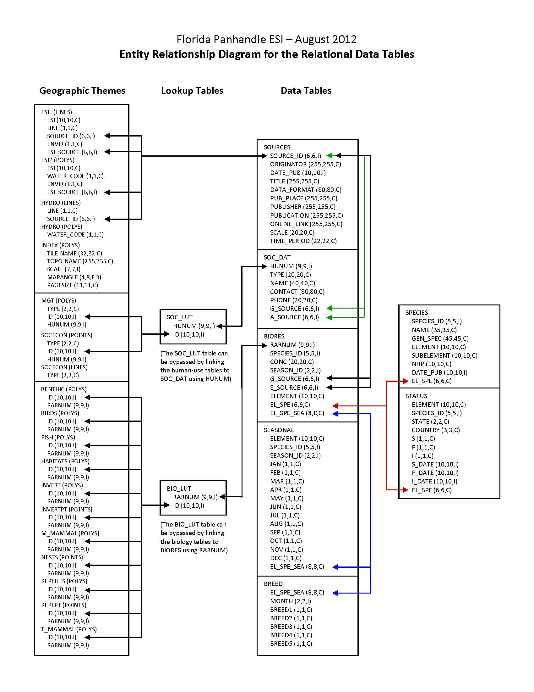
In addition to the geographic data layers, six relational attribute or data tables (BIORES, BREED, SEASONAL, SOURCES, SPECIES, and STATUS) are used to store the complex biological data in the ESI data structure. The geographic data layer containing biological resource information (in this case, BIRDS) is linked to the Biological Resources table (BIORES) using the unique ID and the lookup table BIO_LUT, or it can be linked directly using RARNUM. The ID is a unique combination of the atlas number (for the Florida Panhandle atlas, the number is 218), an element/layer specific number (BIRDS are layer 1, FISH are layer 2, etc.), and a unique record number. The RARNUM represents a unique combination of species, seasonalities, concentrations, and source information. For each of these groupings, a number is generated. That number is concatenated with the atlas number to create a "resource at risk" number that is unique across atlases. BIORES and the other relational data tables are described in the Detailed_Description sections. See the Browse_Graphic section for a link to the entity-relationship diagram, which describes the way these tables relate to the geographic data layers and other attribute tables in the ESI data structure. Due to the complexity of the relational database model, the data items are also post-processed into a flat file format. This table, called BIOFILE, may be used in place of the relational files to ease simple data queries. The items in the flat file are ELEMENT, SUBELEMENT, NAME, GEN_SPEC, S, F, NHP, DATE_PUB, CONC, JAN, FEB, MAR, APR, MAY, JUN, JUL, AUG, SEP, OCT, NOV, DEC, BREED1, BREED2, BREED3, BREED4, BREED5, RARNUM, G_SOURCE, S_SOURCE, and BREED. All of these items are the same as their counterparts in the individual data tables (described in the Detailed_Description sections), except the BREED1-BREED5 and BREED items. BREED is a newly generated variable used to link to the BREED_DT data table, a modified, more compact version of the relational BREED data table. BREED1-BREED5 give a text summary of when each life stage occurs within the associated map object. The life stages referred to are the same as those listed in the Detailed_Description of the BREED data table. The link to the BIOFILE may be made through the BIO_LUT, using ID to link to RARNUM, or BIOFILE may be linked directly to the RARNUM in each of the geographic layer's attribute data tables. As mentioned, BREED_DT is an auxiliary support data table to the flat file structure, which allows the user to do searches based on month for seasonal breeding activities. The link from the flat file to BREED_DT is the BREED item. A second supporting data table is SOURCES. This is the same as the source file described above, and the link from the flat file is both G_SOURCE and S_SOURCE. It should be noted that although the flat file eases data query, it is not a normalized database structure, and actual updates performed by the states and other responsible agencies should be done using the relational data tables. The entity-relationship diagram, describing relationships between attribute tables in the ESI data structure does NOT include the BIOFILE data table, and this data table is NOT described in a Detailed_Description section. |
| Entity Attribute Detail Citation: |
A complete description of entity types, attributes, and attribute values for ESI atlases can be found in the NOAA ESI Guidelines (http://response.restoration.noaa.gov/esi_guidelines). |
| Distribution Liability: |
These data represent a snapshot in time and temporal changes may have occurred. These data are not intended to include all biological or human-use resources present in an area; they focus on species and resources particularly sensitive to oiling. In the event of a spill, they should be used for a first assessment only. The data providers are the experts with regard to individual resources. They should be contacted to confirm if more current data exist, and/or in-depth information is needed about a particular resource. |
| Data Set Credit: | This project was supported by the National Oceanic and Atmospheric Administration (NOAA), National Ocean Service (NOS), Office of Response and Restoration (OR&R), Emergency Response Division (ERD), Seattle, Washington; the Department of Homeland Security (DHS), United States Coast Guard (USCG), Office of Incident Management and Preparedness, Washington, D.C.; and the Fish and Wildlife Research Institute (FWRI), Florida Fish and Wildlife Conservation Commission, St. Petersburg, Florida. |
Support Roles
Data Steward
| Date Effective From: | 2012-08 |
|---|---|
| Date Effective To: | |
| Contact (Position): | ESI Program Manager |
| Address: |
7600 Sand Point Way NE Seattle, WA 98115 |
| Email Address: | orr.esi@noaa.gov |
Distributor
| Date Effective From: | 2012-08 |
|---|---|
| Date Effective To: | |
| Contact (Position): | ESI Program Manager |
| Address: |
7600 Sand Point Way NE Seattle, WA 98115 |
| Email Address: | orr.esi@noaa.gov |
Metadata Contact
| Date Effective From: | 2012-08 |
|---|---|
| Date Effective To: | |
| Contact (Position): | ESI Program Manager |
| Address: |
7600 Sand Point Way NE Seattle, WA 98115 |
| Email Address: | orr.esi@noaa.gov |
Point of Contact
| Date Effective From: | 2012-08 |
|---|---|
| Date Effective To: | |
| Contact (Position): | ESI Program Manager |
| Address: |
7600 Sand Point Way NE Seattle, WA 98115 |
| Email Address: | orr.esi@noaa.gov |
Extents
| Currentness Reference: | The data were compiled during 2010-2012. The currentness dates for the data range from 1972 to 2012 and are documented in the Lineage section. |
|---|
Extent Group 1
Extent Group 1 / Geographic Area 1
| W° Bound: | -87.625 |
 |
|---|---|---|
| E° Bound: | -83.684 | |
| N° Bound: | 30.747 | |
| S° Bound: | 28.277 |
Extent Group 1 / Time Frame 1
| Time Frame Type: | Range |
|---|---|
| Start: | 1972 |
| End: | 2012 |
Spatial Information
Spatial Representation
Representations Used
| Vector: | Yes |
|---|
Vector Representation 1
| Complex Object Present?: | Yes |
|---|---|
| Complex Object Count: | 1680 |
| Curve Object Present?: | Yes |
| Curve Object Count: | 764880 |
| Point Object Present?: | Yes |
| Point Object Count: | 1681 |
| Surface Object Present?: | Yes |
| Surface Object Count: | 3660 |
Access Information
| Security Class: | Unclassified |
|---|---|
| Data Access Procedure: |
Contact NOAA for distribution options (see Distributor). ESI data are processed into multiple formats. Distribution formats include a Geodatabase (including an ArcMap .mxd file, complete with database links and symbology), ARC export files, and shapefiles. The database files, available in text and INFO(R) formats, are provided in both the NOAA standard relational database format (see NOAA Technical Memorandum NOS ORCA 115) and in a simplified desktop flat file format. This metadata document includes information about both of these database formats.; |
| Data Access Constraints: |
None |
| Data Use Constraints: |
DO NOT USE MAPS FOR NAVIGATIONAL PURPOSES. Besides the above warning, there are no use constraints on these data. Note that the ESI database should not be used to the exclusion of other pertinent data or information held by state or federal agencies or other organizations. Likewise, information contained in the database cannot be used in place of consultations with environmental, natural resource, and cultural resource agencies, or in place of field surveys. Recognize that the information contained in the ESI database represents known concentration areas or occurrences of natural, cultural, and human-use resources, but does not necessarily represent the full distribution or range of each species or resource. This is particularly important to recognize when considering potential impacts to protected resources, such as endangered species, wetlands, etc. Acknowledgment of the originators, publishers, contributors, and sources listed would be appreciated in products derived from these data. |
Distribution Information
Distribution 1
| Download URL: | http://response.restoration.noaa.gov/esi_download |
|---|---|
| Distributor: | |
| Description: |
Downloadable Data |
| File Type (Deprecated): | Multiple formats |
URLs
URL 1
| URL: | http://response.restoration.noaa.gov/esi |
|---|---|
| URL Type: |
Online Resource
|
URL 2
| URL: | http://response.restoration.noaa.gov/esi_download |
|---|---|
| URL Type: |
Online Resource
|
URL 3
| URL: | http://response.restoration.noaa.gov/esi_guidelines |
|---|---|
| URL Type: |
Online Resource
|
URL 4
| URL: | http://response.restoration.noaa.gov/sites/default/files/esimaps/gisdata/FloridaPanhdle_2012_datafig.jpg |
|---|---|
| URL Type: |
Browse Graphic
|
| File Resource Format: | JPEG |
| Description: |
Depicts the relationships between spatial data layers and attribute data tables for the Florida Panhandle ESI data. |
URL 5
| URL: | http://response.restoration.noaa.gov/sites/default/files/esimaps/gisdata/FloridaPanhdle_2012_datafig2.jpg |
|---|---|
| URL Type: |
Browse Graphic
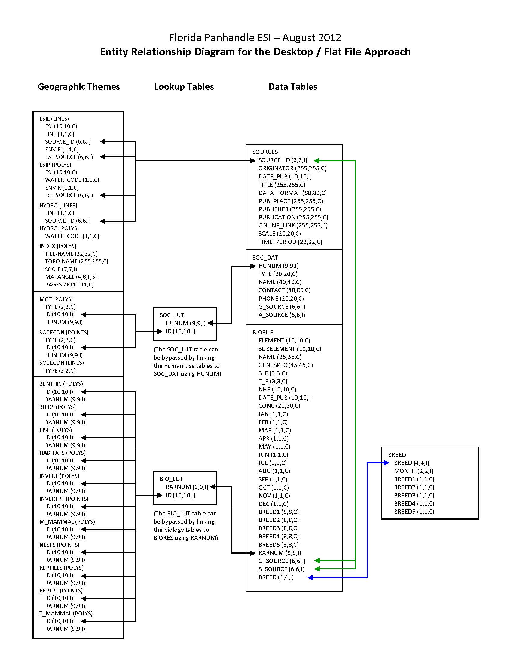
|
| File Resource Format: | JPEG |
| Description: |
Depicts the relationships between spatial data layers and desktop data tables for the Florida Panhandle ESI data. |
Activity Log
Activity Log 1
| Activity Date/Time: | 2014-06-09 |
|---|---|
| Description: |
Date that the source FGDC record was last modified. |
Activity Log 2
| Activity Date/Time: | 2017-04-05 |
|---|---|
| Description: |
Converted from Content Standards for Digital Geospatial Metadata (version FGDC-STD-001-1998) using 'fgdc_to_inport_xml.pl' script. Contact Tyler Christensen (NOS) for details. |
Activity Log 3
| Activity Date/Time: | 2017-09-13 |
|---|---|
| Description: |
Partial upload of Spatial Info section only. |
Activity Log 4
| Activity Date/Time: | 2017-11-01 |
|---|---|
| Description: |
Replaced entire Lineage section to populate new Source Contribution field. |
Activity Log 5
| Activity Date/Time: | 2018-02-08 |
|---|---|
| Description: |
Partial upload of Positional Accuracy fields only. |
Technical Environment
| Description: |
The software packages used to develop the atlas are Environmental Systems Research Institute's ARC/INFO(R) (version 9.3) and SQL SERVER(R) (version 2000). The hardware configuration is PCs with Windows Operating System (2000/XP/2003). The Spatial_Data_Organization Information section refers only to the source files in the ARC export format. The following files are included in the data set: benthic.e00, birds.e00, esil.e00, esip.e00, fish.e00, habitats.e00, hydro.e00, index.e00, invert.e00, invertpt.e00, m_mammal.e00, mgt.e00, nests.e00, reptiles.e00, reptpt.e00, socecon.e00, and t_mammal.e00. Associated relational and desktop data tables provided in Arc export and text format are bio_lut.e00, biofile.e00, biores.e00, breed.e00, breed_dt.e00, seasonal.e00, soc_dat.e00, soc_lut.e00, sources.e00, species.e00, and status.e00. |
|---|
Data Quality
| Accuracy: |
A multi-stage error checking process is used to verify both attribute accuracy and logical consistency throughout data production. The process includes a standardized data entry methodology, hardcopy data review by in-house and external resource experts, a final Quality Assurance/Quality Control (QA/QC) process, and multiple automated logical consistency checks. Quantitative data (such as densities, counts, abundances, or concentrations) provided by resource experts for inclusion in the data set may vary widely in attribute accuracy, depending upon the methodology used to collect and compile such data. For a more detailed evaluation of source data attribute accuracy, contact the sources listed in the Lineage section. |
|---|---|
| Horizontal Positional Accuracy: |
Spatial components for the biological data layers can come from expert interviews, hardcopy, or digital sources. Some of the spatial components of the biological data layers may have been developed using regional experts who estimate concentration areas. It is difficult to estimate the positional accuracy of such data, except to state that they are compiled on hardcopy base maps with a scale of 1:24,000. Some of the spatial components of the biological data sets are developed from pre-existing digital or hardcopy sources and reflect the positional accuracy of these original data. Note that biological resource data by their very nature are considered "fuzzy", and this should be understood when considering the positional accuracy of vector digital objects representing these resources. See the Lineage and Process_Description sections for more information on the original source data and how these data were integrated or manipulated to create the final data set. |
| Completeness Report: |
These data represent a synthesis of expert knowledge, available hardcopy documents, survey data, maps, and digital data on bird nesting, wintering, migratory staging and other spatial/temporal concentration areas. See also the NESTS data layer, part of the larger Florida Panhandle ESI database, for additional bird information. These data do not necessarily represent all bird occurrences in Florida Panhandle. The following species are included in this data set: (Species_ID, Common Name, Scientific Name [n/a if not applicable]): 1, Common loon, Gavia immer; 8, Double-crested cormorant, Phalacrocorax auritus; 12, Canada goose, Branta canadensis; 15, Snow goose, Chen caerulescens; 16, Mallard, Anas platyrhynchos; 17, Northern pintail, Anas acuta; 18, Green-winged teal, Anas crecca; 20, Northern shoveler, Anas clypeata; 21, Canvasback, Aythya valisineria; 23, Lesser scaup, Aythya affinis; 24, Common goldeneye, Bucephala clangula; 26, Bufflehead, Bucephala albeola; 27, Long-tailed duck, Clangula hyemalis; 33, Red-breasted merganser, Mergus serrator; 34, American coot, Fulica americana; 38, Herring gull, Larus argentatus; 40, Ring-billed gull, Larus delawarensis; 45, Common tern, Sterna hirundo; 54, Great blue heron, Ardea herodias; 55, Whimbrel, Numenius phaeopus; 58, Greater yellowlegs, Tringa melanoleuca; 59, Lesser yellowlegs, Tringa flavipes; 60, Red knot, Calidris canutus; 62, Least sandpiper, Calidris minutilla; 63, Dunlin, Calidris alpina; 64, Short-billed dowitcher, Limnodromus griseus; 66, Western sandpiper, Calidris mauri; 67, Sanderling, Calidris alba; 69, Semipalmated plover, Charadrius semipalmatus; 70, Killdeer, Charadrius vociferus; 71, Black-bellied plover, Pluvialis squatarola; 73, Ruddy turnstone, Arenaria interpres; 76, Bald eagle, Haliaeetus leucocephalus; 77, Osprey, Pandion haliaetus; 86, Least tern, Sternula antillarum; 87, Little blue heron, Egretta caerulea; 88, Great egret, Ardea alba; 89, Snowy egret, Egretta thula; 90, Black-crowned night-heron, Nycticorax nycticorax; 91, Glossy ibis, Plegadis falcinellus; 93, Cattle egret, Bubulcus ibis; 94, Tricolored heron, Egretta tricolor; 97, Green heron, Butorides virescens; 98, Laughing gull, Larus atricilla; 107, Peregrine falcon, Falco peregrinus; 115, White ibis, Eudocimus albus; 118, Brown pelican, Pelecanus occidentalis; 120, Yellow-crowned night-heron, Nyctanassa violacea; 124, Redhead, Aythya americana; 127, Sooty tern, Onychoprion fuscatus; 132, Wood stork, Mycteria americana; 133, Black skimmer, Rynchops niger; 134, Gull-billed tern, Gelochelidon nilotica; 135, Sandwich tern, Thalasseus sandvicensis; 136, Caspian tern, Hydroprogne caspia; 137, Royal tern, Thalasseus maximus; 138, Forster's tern, Sterna forsteri; 139, Snowy plover, Charadrius alexandrinus; 141, American avocet, Recurvirostra americana; 142, Black-necked stilt, Himantopus mexicanus; 148, Ruddy duck, Oxyura jamaicensis; 152, American oystercatcher, Haematopus palliatus; 153, Piping plover, Charadrius melodus; 154, Wilson's plover, Charadrius wilsonia; 155, Willet, Catoptrophorus semipalmatus; 162, Gadwall, Anas strepera; 163, Reddish egret, Egretta rufescens; 167, Northern gannet, Morus bassanus; 169, American wigeon, Anas americana; 173, American white pelican, Pelecanus erythrorhynchos; 180, Ring-necked duck, Aythya collaris; 181, Northern harrier, Circus cyaneus; 186, American black duck, Anas rubripes; 190, Blue-winged teal, Anas discors; 191, Wood duck, Aix sponsa; 193, Black tern, Chlidonias niger; 210, Marbled godwit, Limosa fedoa; 211, Mottled duck, Anas fulvigula; 220, Merlin, Falco columbarius; 265, Whooping crane, Grus americana; 277, Seaside sparrow, Ammodramus maritimus; 293, Yellowlegs, Tringa spp.; 299, Scaup, Aythya spp.; 302, Scoters, Melanitta spp.; 305, Red-cockaded woodpecker, Picoides borealis; 406, Cinnamon teal, Anas cyanoptera; 459, Florida burrowing owl, Athene cunicularia floridana; 859, Scott's seaside sparrow, Ammodramus maritimus peninsulae; 1002, Shorebirds, n/a; 1003, Waterfowl, n/a; 1004, Wading birds, n/a; 1005, Raptors, n/a; 1008, Terns, n/a; 1021, Ducks, n/a. |
| Conceptual Consistency: |
A multi-stage error checking process, described in the above Attribute_Accuracy_Report, is used to verify both attribute accuracy and logical consistency throughout data production. This process includes multiple automated logical consistency checks that test the files for missing or duplicate data, rules for proper coding, GIS topological consistencies (such as dangles, unnecessary nodes, etc.), and SQL SERVER(R) to ARC/INFO(R) consistencies. After the data are delivered to NOAA, they are again subjected to a number of quality and consistency checks. In the process of checking for topological and database consistencies, new IDs and RARNUMs or HUNUMs are also generated. The new IDs are a combination of atlas number, element number, and record number. In addition, the value used to represent the element is modified to reflect the type of feature being mapped. In the case of an element that is normally represented by a point or polygon, a value of 20 is added to the standard element value for mapping of linear features. In the case where an element usually mapped as a polygon is represented by a point, a value of 30 is added to the regular element value. The RARNUMs are also modified to include the atlas number, so multiple atlases can be combined and RARNUMs remain unique. RARNUMs are redefined on an element basis, so "resources at risk" groupings will contain only a single element. HUNUMs are also modified to include the atlas number. |
Lineage
Sources
A REPORT ON THE SHOREBIRD SURVEY CONDUCTED BY THE CHOCTAWHATCHEE AUDUBON SOCIETY (3 JUL-9 OCT 2010)
| Contact Name: | WARE, D. AND G. PARSONS (CHOCTAWHATCHEE AUDUBON SOCIETY) |
|---|---|
| Publish Date: | 2010-01-01 |
| Extent Type: | Discrete |
| Extent Start Date/Time: | 2010 |
| Source Contribution: |
BIRDS INFORMATION | Source Geospatial Form: POWERPOINT | Type of Source Media: online |
APALACHICOLA RIVERKEEPER: SAVING AN AMERICAN TREASURE
| Contact Name: | APALACHICOLA RIVERKEEPER |
|---|---|
| Publish Date: | 2011-01-01 |
| Extent Type: | Discrete |
| Extent Start Date/Time: | 2011 |
| Citation URL: | http://www.apalachicolariverkeeper.org |
| Source Contribution: |
BIRDS INFORMATION | Source Geospatial Form: vector digital data | Type of Source Media: online |
AQUATIC PRESERVE RESOURCES
| Contact Name: | ALEXANDER, S., FLORIDA DEPARTMENT OF ENVIRONMENTAL PROTECTION (FL DEP) |
|---|---|
| Publish Date: | 2011-01-01 |
| Extent Type: | Discrete |
| Extent Start Date/Time: | 2011 |
| Source Contribution: |
BIRDS INFORMATION | Source Geospatial Form: EXPERT KNOWLEDGE | Type of Source Media: PERSONAL COMMUNICATION |
BIRDS, REPTILES, AMPHIBIANS, AND OTHER PANHANDLE COASTAL RESOURCES
| Contact Name: | HIMES, J., FWC-FWRI (FLORIDA FISH AND WILDLIFE CONSERVATION COMMISSION-FISH AND WILDLIFE RESEARCH INSTITUTE) |
|---|---|
| Publish Date: | 2011-01-01 |
| Extent Type: | Discrete |
| Extent Start Date/Time: | 2011 |
| Source Contribution: |
BIRDS INFORMATION | Source Geospatial Form: EXPERT KNOWLEDGE | Type of Source Media: PERSONAL COMMUNICATION |
BNB (BEACH-NESTING BIRDS)
| Contact Name: | FLORIDA FISH AND WILDLIFE CONSERVATION COMMISSION (FWC) |
|---|---|
| Publish Date: | 2010-01-01 |
| Extent Type: | Range |
| Extent Start Date/Time: | 2005 |
| Extent End Date/Time: | 2010 |
| Citation URL: | http://legacy.myfwc.com/bnb/ |
| Source Contribution: |
BIRDS INFORMATION | Source Geospatial Form: vector digital data | Type of Source Media: EMAIL |
CAS SHOREBIRD SURVEY SUMMARY
| Contact Name: | CHOCTAWHATCHEE AUDUBON SOCIETY (CAS) |
|---|---|
| Publish Date: | 2010-01-01 |
| Extent Type: | Discrete |
| Extent Start Date/Time: | 2010 |
| Source Contribution: |
BIRDS INFORMATION | Source Geospatial Form: spreadsheet | Type of Source Media: EMAIL |
DISTRIBUTION OF SHOREBIRDS AND OTHER SPECIES IN THE FL PANHANDLE
| Contact Name: | KELLY, P., USFWS (U.S. FISH AND WILDLIFE SERVICE) |
|---|---|
| Publish Date: | 2011-01-01 |
| Extent Type: | Discrete |
| Extent Start Date/Time: | 2011 |
| Source Contribution: |
BIRDS INFORMATION | Source Geospatial Form: EXPERT KNOWLEDGE | Type of Source Media: PERSONAL COMMUNICATION |
DIVING AND RECREATIONAL FISHING SITES IN WATERS OF FLORIDA PANHANDLE
| Contact Name: | KNUDSEN, RICHARD (FWRI) |
|---|---|
| Publish Date: | 2011-01-01 |
| Extent Type: | Discrete |
| Extent Start Date/Time: | 2011 |
| Source Contribution: |
BIRDS INFORMATION | Source Geospatial Form: EXPERT KNOWLEDGE | Type of Source Media: PERSONAL COMMUNICATION |
ELEMENT OCCURRENCE POLYGON DATA LAYER
| Contact Name: | FLORIDA NATURAL AREAS INVENTORY (FNAI) |
|---|---|
| Publish Date: | 2011-01-01 |
| Extent Type: | Discrete |
| Extent Start Date/Time: | 2011 |
| Source Contribution: |
BIRDS INFORMATION | Source Geospatial Form: vector digital data | Type of Source Media: EMAIL |
FLORIDA SHOREBIRD DATABASE SITES FINAL
| Contact Name: | FLORIDA FISH AND WILDLIFE CONSERVATION COMMISSION (FWC) |
|---|---|
| Publish Date: | 2012-01-01 |
| Extent Type: | Discrete |
| Extent Start Date/Time: | 2012 |
| Source Contribution: |
BIRDS INFORMATION | Source Geospatial Form: vector digital data | Type of Source Media: EMAIL |
FLORIDA'S BIRDS: A FIELD GUIDE AND REFERENCE
| Contact Name: | KALE, H.W. II AND D.S. MAEHR |
|---|---|
| Publish Date: | 2009-01-01 |
| Extent Type: | Discrete |
| Extent Start Date/Time: | 2009 |
| Source Contribution: |
BIRDS INFORMATION | Source Geospatial Form: HARDCOPY TEXT | Type of Source Media: PAPER |
GULF ISLANDS NATIONAL SEASHORE/STATE PARK/ESCAMBIA COUNTY RESOURCES: DISTRIBUTION AND ABUNDANCE
| Contact Name: | GULF ISLANDS NATIONAL SEASHORE, ESCAMBIA COUNTY, FLORIDA STATE PARKS |
|---|---|
| Publish Date: | 2012-01-01 |
| Extent Type: | Discrete |
| Extent Start Date/Time: | 2012 |
| Source Contribution: |
BIRDS INFORMATION | Source Geospatial Form: EXPERT KNOWLEDGE | Type of Source Media: PERSONAL COMMUNICATION |
LEAST_TE (LEAST TERN)
| Contact Name: | GULF ISLANDS NATIONAL SEASHORE (NPS) |
|---|---|
| Publish Date: | 2010-01-01 |
| Extent Type: | Discrete |
| Extent Start Date/Time: | 2010 |
| Source Contribution: |
BIRDS INFORMATION | Source Geospatial Form: vector digital data | Type of Source Media: ftp |
MIDWINTER REDHEAD SURVEY ALONG THE GULF OF MEXICO, 1981-2010
| Contact Name: | U.S. FISH AND WILDLIFE SERVICE (USFWS) |
|---|---|
| Publish Date: | 2010-01-01 |
| Extent Type: | Range |
| Extent Start Date/Time: | 1981 |
| Extent End Date/Time: | 2010 |
| Source Contribution: |
BIRDS INFORMATION | Source Geospatial Form: HARDCOPY TEXT | Type of Source Media: EMAIL |
MIDWINTER WATERFOWL INVENTORY (MWI) FL CORRECTED DATA
| Contact Name: | FLORIDA FISH AND WILDLIFE CONSERVATION COMMISSION - FISH AND WILDLIFE RESEARCH INSTITUTE (FWC-FWRI) |
|---|---|
| Publish Date: | 2003-01-01 |
| Extent Type: | Range |
| Extent Start Date/Time: | 1972 |
| Extent End Date/Time: | 2003 |
| Source Contribution: |
BIRDS INFORMATION | Source Geospatial Form: spreadsheet | Type of Source Media: EMAIL |
PIPING PLOVER HABITAT
| Contact Name: | USAF EGLIN AIR FORCE BASE |
|---|---|
| Publish Date: | 2007-01-01 |
| Extent Type: | Discrete |
| Extent Start Date/Time: | 2007 |
| Source Contribution: |
BIRDS INFORMATION | Source Geospatial Form: vector digital data | Type of Source Media: EMAIL |
RED KNOT FOR ESI
| Contact Name: | U.S. FISH AND WILDLIFE SERVICE (USFWS) |
|---|---|
| Publish Date: | 2012-01-01 |
| Extent Type: | Discrete |
| Extent Start Date/Time: | 2012 |
| Source Contribution: |
BIRDS INFORMATION | Source Geospatial Form: vector digital data | Type of Source Media: disc |
SENSITIVITY OF COASTAL ENVIRONMENTS AND WILDLIFE TO SPILLED OIL: WEST FLORIDA ATLAS
| Contact Name: | NATIONAL OCEANIC AND ATMOSPHERIC ADMINISTRATION (NOAA), NATIONAL OCEAN SERVICE (NOS), OFFICE OF RESPONSE AND RESTORATION (OR&R), EMERGENCY RESPONSE DIVISION (ERD) |
|---|---|
| Publish Date: | 1995-01-01 |
| Extent Type: | Discrete |
| Extent Start Date/Time: | 1995 |
| Scale Denominator: | 50000 |
| Citation URL: | http://response.restoration.noaa.gov/esi |
| Source Contribution: |
BIRDS INFORMATION | Source Geospatial Form: HARDCOPY MAP | Type of Source Media: paper |
SNOWY PLOVER MASTER
| Contact Name: | USAF EGLIN AIR FORCE BASE |
|---|---|
| Publish Date: | 2009-01-01 |
| Extent Type: | Discrete |
| Extent Start Date/Time: | 2009 |
| Source Contribution: |
BIRDS INFORMATION | Source Geospatial Form: vector digital data | Type of Source Media: EMAIL |
ST MARKS NWR BREEDING WIPL PAIRS AND NESTS
| Contact Name: | ST. MARKS NATIONAL WILDLIFE REFUGE (USFWS) |
|---|---|
| Publish Date: | 2007-01-01 |
| Extent Type: | Discrete |
| Extent Start Date/Time: | 2007 |
| Source Contribution: |
BIRDS INFORMATION | Source Geospatial Form: spreadsheet | Type of Source Media: EMAIL |
ST. MARKS NATIONAL WILDLIFE REFUGE RESOURCES
| Contact Name: | REINMAN, JOSEPH (USFWS) |
|---|---|
| Publish Date: | 2011-01-01 |
| Extent Type: | Discrete |
| Extent Start Date/Time: | 2011 |
| Source Contribution: |
BIRDS INFORMATION | Source Geospatial Form: EXPERT KNOWLEDGE | Type of Source Media: PERSONAL COMMUNICATION |
STATE PARK RESOURCES FOR FLORIDA PANHANDLE
| Contact Name: | HARVEY, A. (BIG LAGOON STATE PARK) |
|---|---|
| Publish Date: | 2011-01-01 |
| Extent Type: | Discrete |
| Extent Start Date/Time: | 2011 |
| Source Contribution: |
BIRDS INFORMATION | Source Geospatial Form: EXPERT KNOWLEDGE | Type of Source Media: PERSONAL COMMUNICATION |
TERNS
| Contact Name: | GULF ISLANDS NATIONAL SEASHORE (NPS) |
|---|---|
| Publish Date: | 2010-01-01 |
| Extent Type: | Discrete |
| Extent Start Date/Time: | 2010 |
| Source Contribution: |
BIRDS INFORMATION | Source Geospatial Form: vector digital data | Type of Source Media: FTP SITE |
THE IMPORTANT BIRD AREAS OF FLORIDA, SPECIAL PUBLICATION NO. 8
| Contact Name: | PRANTY, B., R.F. NOSS, AND S.SINGH (EDS.) |
|---|---|
| Publish Date: | 2010-01-01 |
| Extent Type: | Discrete |
| Extent Start Date/Time: | 2010 |
| Source Contribution: |
BIRDS INFORMATION | Source Geospatial Form: HARDCOPY TEXT | Type of Source Media: EMAIL |
Process Steps
Process Step 1
| Description: |
Three main sources of data were used to depict bird distribution and seasonality for this data layer: 1) personal interviews with resource experts from the U.S. Fish and Wildlife Service (USFWS), Gulf Islands National Seashore (GINS), Florida Fish and Wildlife Conservation Commission (FFWCC), Forida Department of Environmental Protection (DEP), Florida Audubon, and Big Lagoon State Park; 2) digital data sets and survey data provided by: FFWCC, GINS, USFWS, St. Marks National Wildlife Refuge (NWR), Florida Natural Areas Inventory (FNAI), Eglin Air Force Base; and 3) published and unpublished reports. The above digital and/or hardcopy sources were compiled by the project biologist to create the BIRDS data layer. Depending on the type of source data, three general approaches are used for compiling the data layer: 1) information gathered during initial interviews and from hardcopy sources are compiled onto U.S. Geological Survey 1:24,000 topographic quadrangles and digitized; 2) hardcopy maps are digitized at their source scale; 3) digital data layers are evaluated and used "as is" or integrated with the hardcopy data sources. See the Lineage section for additional information on the type of source data for this data layer. The compiled ESI, biology, and human-use data are plotted onto hardcopy draft maps. Following the delivery of draft maps to the participating resource experts, a second set of interviews are conducted to review the maps. If necessary, edits to the BIRDS data layer are made based on the recommendations of the resource experts, and final hardcopy maps and digital data are created. |
|---|---|
| Process Date/Time: | 2012-08-01 00:00:00 |
Child Items
Catalog Details
| Catalog Item ID: | 40712 |
|---|---|
| GUID: | gov.noaa.nmfs.inport:40712 |
| Metadata Record Created By: | Tyler Christensen |
| Metadata Record Created: | 2017-04-05 14:53+0000 |
| Metadata Record Last Modified By: | SysAdmin InPortAdmin |
| Metadata Record Last Modified: | 2023-05-30 18:09+0000 |
| Metadata Record Published: | 2018-02-08 |
| Owner Org: | ORR |
| Metadata Publication Status: | Published Externally |
| Do Not Publish?: | N |
| Metadata Last Review Date: | 2018-02-08 |
| Metadata Review Frequency: | 1 Year |
| Metadata Next Review Date: | 2019-02-08 |