Willapa Bay, Washington Benthic Habitats 1995 Biotic
Data Set (DS) | Office for Coastal Management (OCM)GUID: gov.noaa.nmfs.inport:47992 | Updated: May 30, 2023 | Published / External
Summary
Short Citation
Office for Coastal Management, 2025: Willapa Bay, Washington Benthic Habitats 1995 Biotic, https://www.fisheries.noaa.gov/inport/item/47992.
Full Citation Examples
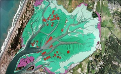
In June 1995, the Columbia River Estuary Study Taskforce (CREST) acquired 295 true color aerial photographs (1:12,000) of Willapa Bay, Washington, from the State of Washington Department of Transportation (WDOT), suitable for the interpretation of submerged rooted aquatic vascular plant populations. In August 1995, field surveys were conducted by a team composed of staff from Oregon State University, CREST, and the Washington Department of Natural Resources, for spectral signature development and verification as well as habitat observation. The submerged plant populations were interpreted and mapped from the photographs and transferred onto State of Washington 1:12,000 Orthophoto maps (USGS 7.5' quadrangle). The interpretations were digitized into a geographic information system (GIS) for the creation of a habitat polygon map. All interpretation, digitization and photography acquisition were according to stringent parameters detailed in the Coastal Change Analysis Program (C-CAP) Protocol (NMFS Technical Document 123). Two datasets were used as ancillary information to complement the interpreted habitat polygons. In 1996, color aerial videography was obtained from WDOT for post mapping verification and accuracy assessments. Marine Resources Consultants, Inc. and the University of Washington collected videography from 29 underwater transects to verify the deep-water edge of selected seagrass beds in the southern portion of the bay. The date, time, geographic coordinates and depth were updated every 2 to 4 seconds and recorded directly on the videotape images. Latitude and longitude were provided by a differentially corrected global positioning system (GPS). The initial presence/absence map of SAV produced by CREST was later segmented by depth to discriminate between two very different seagrass communities and support field accuracy assessment. Final field verification of the data by personnel from CREST and the NOAA Office for Coastal Management was conducted in the Summer of 1997. The benthic data is classified according to the System for Classification of Habitats in Estuarine and Marine Environments (SCHEME). This system is fully described in "Development of a System for Classification of Habitats in Estuarine and Marine Environments (SCHEME) for Florida, Report to U.S. EPA - Gulf of Mexico Program, Florida Fish and Wildlife Conservation Commission, Florida Marine Research Institute. Review Draft 12/04/02."
Original contact information:
Contact Org: NOAA Office for Coastal Management
Phone: 843-740-1202
Email: coastal.info@noaa.gov
Distribution Information
Controlled Theme Keywords
BENTHIC, COASTAL, environment, ESTUARY
Child Items
| Type | Title |
|---|---|
| Entity | Biotic |
Contact Information
Point of Contact
NOAA Office for Coastal Management (NOAA/OCM)
coastal.info@noaa.gov
(843) 740-1202
https://coast.noaa.gov
Metadata Contact
NOAA Office for Coastal Management (NOAA/OCM)
coastal.info@noaa.gov
(843) 740-1202
https://coast.noaa.gov
Extents


1995-06-28