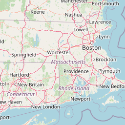
2011 USACE NCMP Topobathy Lidar: MA & NH
Data Set (DS) | OCM Partners (OCMP)GUID: gov.noaa.nmfs.inport:49843 | Updated: October 17, 2023 | Published / External
Summary
Short Citation
OCM Partners, 2025: 2011 USACE NCMP Topobathy Lidar: MA & NH, https://www.fisheries.noaa.gov/inport/item/49843.
Full Citation Examples
These files contain classified topographic and bathymetric lidar data as unclassified valid topographic data (1), valid topographic data classified as ground (2), noise (7), and valid bathymetric data (11). Classes 1, 2 and 7 are defined in accordance with the American Society for Photogrammetry and Remote Sensing (ASPRS) classification standards, while class 11 is specific to NOAA OCM. These data were collected by the Compact Hydrographic Airborne Rapid Total Survey (CHARTS) system along the coast of Massachusetts and New Hampshire. CHARTS integrates topographic and bathymetric lidar sensors, a digital camera and a hyperspectral imager on a single remote sensing platform for use in coastal mapping and charting activities. Data coverage generally extends along the coastline from the waterline inland 500 meters (topography) and offshore 1,000 meters or to laser extinction (bathymetry). Native lidar data is not generally in a format accessible to most Geographic Information Systems (GIS). Specialized in-house and commercial software packages are used to process the native lidar data into 3-dimensional positions that can be imported into GIS software for visualization and further analysis. The 3-D position data are sub-divided into a series of LAS files, each covering approximately 5 kilometers of shoreline. The format of the file is LAS version 1.2.
In addition to these lidar point data, the bare earth Digital Elevation Models (DEM) created from the lidar point data are also available. These data are available for custom download at the link provided in the URL section of this metadata record.
Distribution Information
-
Create custom data files by choosing data area, product type, map projection, file format, datum, etc.
-
LAS/LAZ - LASer
Simple download of data files.
None
Users should be aware that temporal changes may have occurred since this data set was collected and some parts of this data may no longer represent actual surface conditions. Users should not use this data for critical applications without a full awareness of its limitations. These data depict the heights at the time of the survey and are only accurate for that time. Acknowledgement of the Joint Airborne Lidar Bathymetry Technical Center of eXpertise (JALBTCX) would be appreciated in any publications or derived products.
Controlled Theme Keywords
elevation
Child Items
No Child Items for this record.
Contact Information
Point of Contact
NOAA Office for Coastal Management (NOAA/OCM)
coastal.info@noaa.gov
(843) 740-1202
https://coast.noaa.gov
Metadata Contact
NOAA Office for Coastal Management (NOAA/OCM)
coastal.info@noaa.gov
(843) 740-1202
https://coast.noaa.gov
Extents


2011-09-25 - 2011-09-30