2022 NOAA Topobathy Lidar DEM: Morro Bay, CA
Data Set (DS) | Office for Coastal Management (OCM)GUID: gov.noaa.nmfs.inport:67998 | Updated: January 10, 2024 | Published / External
Summary
Short Citation
Office for Coastal Management, 2025: 2022 NOAA Topobathy Lidar DEM: Morro Bay, CA, https://www.fisheries.noaa.gov/inport/item/67998.
Full Citation Examples
Morro Bay 2022 topobathymetric Lidar area data were collected by NV5 Geospatial (NV5) using a Riegl VQ880GII system. Morro Bay 2022 data acquisition occurred on 20220614 in two missions. The Morro Bay 2022 dataset includes topobathymetric data in a LAS format 1.4, point data record format 6, with the following classifications in accordance with project specifications and the American Society for Photogrammetry and Remote Sensing (ASPRS) classification standards:
1 - unclassified
1O - edge clip
2 - ground
7W - low noise
9 - NIR water surface
18W - high noise
40 - bathymetric bottom or submerged topography
41 - Green water surface
43 - Submerged object, not otherwise specified (For Morro Bay, oyster reefs have this classification, even though exposed at
low tide)
45 - water column
This data set also includes lidar intensity values, number of returns, return number, time, and scan angle. The 100 meter buffered project area covers approximately 4,215 acres along the south central Pacific Coast of California near the town of Los Osos. LAS files were compiled in 500 m x 500 m tiles clipped to the project boundary. The final classified Lidar data were used to create topobathymetric DEMs in GeoTIFF format with 1m pixel resolution. This delivery of the Morro Bay 2022 dataset represents an area covering 96 - 500 m x 500 m DEM tiles clipped to the project boundary. One tile (MRR22_088) did not have any valid bathymetric bottom or ground points and so it did not produce a valid dem. This Project was completed in partnership between NOAA OCM and the NEP.
In addition to these bare earth Digital Elevation Model (DEM) data, the lidar point data that these DEM data were created from, are also available. These data are available for custom download at the link provided in the URL section of this metadata record.
Distribution Information
-
Create custom data files by choosing data area, map projection, file format, etc. A new metadata will be produced to reflect your request using this record as a base.
-
GeoTIFF
Bulk download of data files in the original coordinate system.
None
Users should be aware that temporal changes may have occurred since this data set was collected and some parts of this data may no longer represent actual surface conditions. Users should not use this data for critical applications without a full awareness of its limitations.
Controlled Theme Keywords
COASTAL BATHYMETRY, COASTAL ELEVATION, DIGITAL ELEVATION/TERRAIN MODEL (DEM), elevation, TERRAIN ELEVATION
Child Items
No Child Items for this record.
Contact Information
Point of Contact
NOAA Office for Coastal Management (NOAA/OCM)
coastal.info@noaa.gov
(843) 740-1202
https://coast.noaa.gov
Metadata Contact
NOAA Office for Coastal Management (NOAA/OCM)
coastal.info@noaa.gov
(843) 740-1202
https://coast.noaa.gov
Extents
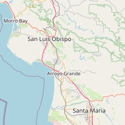


-120.875211° W,
-120.821145° E,
35.373531° N,
35.304796° S
2022-06-14