Researchers have successfully used cameras operated from a helicopter to map surface water temperatures in Maine’s Narraguagus River. This is an important step toward habitat conservation for endangered Atlantic salmon and other migratory fish.
“This pilot project is part of our work to locate the habitat that we need to protect, restore, and enhance to ensure these fish can continue to live there,” said John Kocik, a researcher on the project who also leads our Atlantic salmon ecosystems research effort. “This work not only improves prospects for fish, but also for people since high-functioning watersheds are fundamental to quality of life all along the river.”
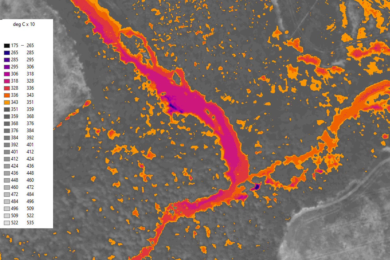
The results will provide a snapshot of surface water temperatures in the river. Researchers are particularly focused on cold-water patches that provide refuges for migratory fish as they move up and down the river. Climate change could result in fewer, warmer cold-water refuges.
Researchers are examining data collected by the cameras and will add it to what’s been collected in the same areas of the river by submerged thermometers. There’s also ongoing work to take the temperature of the river bed and the substrate below it where fish sometimes seek colder water. Together these data will form a detailed picture of temperatures in the Narraguagus. They could also help identify where cold water that feeds the river originates and relative size of these refuges under a variety of flow conditions.
Flying the Narraguagus
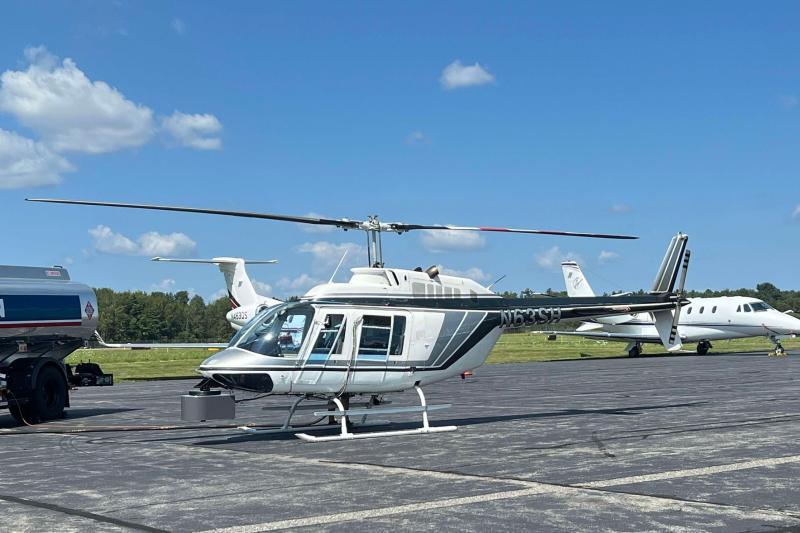
In late August, a team from NV5 took flight in a helicopter fitted with a thermal infrared camera and a color camera. NV5 is a technology and engineering firm that specializes in mapping watersheds, among other geospatial applications. Both cameras were mounted on the aircraft under the cockpit, so the pilot could visually keep the river between her feet and continuously capture the river below.
For the NOAA study area map, the helicopter flew along the main river channel at about 1,000 meters above the ground level at speeds of 40 to 60 knots. The flight was scheduled during the afternoon on a warm, sunny day to ensure thermal contrast between the water in the river and the banks.
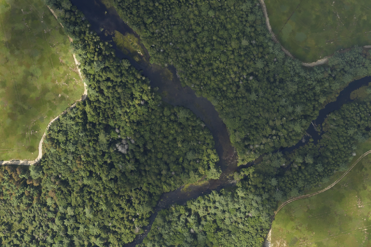
The color camera took high-resolution color images, while the thermal infrared camera next to it captured the heat signatures of the river’s water and its banks. The color camera is capturing images visible to the human eye. The thermal infrared camera is capturing the same area in infrared light, an indicator of the heat given off by the water and surrounding area.
Rivers contain a patchwork of depths, water velocities, water volumes, and temperatures that change over the day and seasons creating a variety of habitats. Species move in and out of this patchwork to find the optimal places to grow, eat, digest their food, rest, avoid predators, and breed. Fish use both warm- and cold-water habitats during their lives, but as rivers warm there is concern that cold-water patches will become scarcer or unusable.
“With this map of the mainstem Narraguagus, we are trying to improve our knowledge of the diversity of thermal habitats to better understand what Atlantic salmon can use and to guide evidence-based restoration,” said Valerie Ouellet from the Atlantic Salmon Federation, who designed the study. “This provides a baseline map we can use to target our efforts where they will be the most effective and ensure that salmon have access to cold-water areas to avoid stress during the warmer time of the year.”
What’s Next for Mapping the Narraguagus
Just like its patchwork of temperatures, the data collection to make a map is also multi-tiered: deployment of temperature recording devices into the river, and aerial infrared mapping. Together, these different technologies allow researchers to understand how river water temperatures are changing and how the different thermal habitats are connected.
“We’re focused on combining the strengths of different sampling and mitigating the sampling differences to make a complete picture,” said Kocik. “The thermal map is only getting the surface. There can be patches of colder or warmer water beneath the surface and even underneath the stream bottom. The point is to figure out the source of the cold water that’s forming a refuge.”
At the top of the stream, in the headwaters and in tributaries, there can be more groundwater and more shading by trees so it is cooler, explains Kocik. As you move downstream, the water typically warms (the stream gets wider and has less shading). The colder water in the main river can come from different sources:
- A tributary with a lot of groundwater sources
- Groundwater seeps coming from the stream bed and banks
- Hyporheic zone downstream of gravel bars, river meanders, and oxbows
“Ideally, we will use this study as a proof-of-concept and evaluate options for future efforts throughout Maine salmon rivers,” said Kocik. “With this success, we can make a case for expanding that effort and inform other partners interested in developing more local capacity.” Ouellet added, ”Everyone understands the importance of water temperature, especially for cold-water species like Atlantic salmon, but it’s hard to fully understand how you go from these thermal maps to inform on-the-ground actions. With this project we are providing a blueprint to show how we can better manage freshwater ecosystems as a whole.”
The mapping project is a collaboration between our center’s Atlantic Salmon Ecosystem Research Branch, the U.S. Department of Agriculture’s Natural Resources Conservation Service and the Atlantic Salmon Federation, funded under President Biden’s Inflation Reduction Act. It provides a blueprint for how to use the information in partnership with the NRCS, while supporting a parallel effort with many partners to replicate this work across Maine.


